Friday, October 28, 2011

Day 16: Back to Sea Turtle

As we were in Manta, we decided to purchase tickets here today for an upcoming futbol (soccer) game between Manta and Barcelona (both Ecuadorian teams). This is a game that we were looking forward to seeing in 3 days. With tickets in hand, we were once again on our way.

We spotted a beach fishing village that looked interesting, so we headed down and through it on the motorcycle. The humble subsistence inhabitants gave us inquisitive, yet friendly, glances.

Fishing pangas at rest

There were tables set up covered with thousands of fish with people quickly cleaning them under a thatched roof - not a job I would volunteer for!

Workers cleaning the sea's bounty

We rode a few miles up the broad, firm, sandy beach and back before exiting back to the main road through farm plots that reminded Jordan of rural Thailand. They even had rice paddies.

After 121 km, we were back where we started on Ruby 16 days ago - Bahía de Caráquez.

Thursday, October 27, 2011

Day 15: Almost the end

In rush hour traffic at 07:00, leaving Guayaquil was challenging, but with numerous stops for directions, we finally made it out of the busy city on our way to Salinas, further out on the coast. Salinas is a popular seaside place for weekenders with its nice beach and setting, and known for chocolates and cheeses among other things. The new 4-lane freeway that connects the two cities was a boring ride over denuded landscape.

Just before we arrived at Salinas, we stopped in Santa Elena where I needed to change some $50's. It seems no one has the least little bit of change in Ecuador and even the hotel last night couldn't change a $50 for the $25 room. After waiting in line at the bank, they wouldn't make change, and with some difficulty, Jordan managed to get their reason - he didn't have an account there. He expressed his frustration for their ridiculous rules and even a helpful client there agreed. Another bank finally accommodated.

We went a little further to Salinas for a lunch on the malecon (the seaside walk so typical in beach towns and cities).

Our final stop was Manta, and as we were feeling a bit frazzled, we didn't feel like searching around for a hotel. Taking the first that looked alright, we checked in, paying more than we had expected for this town. After a bite to eat, we discovered that there were better deals in town, but the owner gave us lots of fresh mangoes off this tree and let us use the kitchen for breakfast, so we didn't feel as disappointed about the price we paid. They watched Jordan make oatmeal with intense curiosity and even asked for a taste!

Another 358 km to add.

Wednesday, October 26, 2011

Day 14: Last Andes pass

Leaving Cuenca Ecuador, we took the southernmost route heading back to the coast. This route was through a national park that displayed a picturesque climb to our last Andes pass.


Jordan forgot to fuel up in Cuenca and Ruby only has a 1.5 gallon tank, good for only about 130 km. The beautiful but lonely scenery distracted us from being conscious of our predicament when Ruby ran out of power. Oh oh, how far are we from the summit? Jordan tipped the bike onto its side to slop whatever little gas there was in the tank to see if we could coax us to the top. We saw a ranger station, and they informed us we were only 2 km from the top and could coast down the other side till we found gas, so off we went for the top. But about 100 m from the summit, Ruby finished the last fumes and said, "Sorry, no more!" Right there were 3 llamas nonchalantly grazing on the sparse high altitude vegetation...


...and after taking photos, we pushed Ruby the last 100 m to the top. We jumped on and coasted for about 4 km and almost missed a small road sign that said "Gasolina" with a lonely hidden restaurant in the bushes which was not much more than a shack. Sure enough she had what we needed and away we went.

We were soon riding above some clouds and looking at them down below us. Then we descended until we were right into the cloud cover with increasing density that necessitated a stop for rain gear. What an experience! Right in the middle of the thick clouds! We had to put our cameras away to protect them from the dampness and then proceed slowly and carefully. (Click to make larger, if you wish.)


As we travelled through the cloud cover, we unfortunately couldn't see what would have been great views of the mountains. but We continued on our descent into an ever increasing tropical flora. When we hit the low flat lands, the moisture relented, and the temperature was quite warm for our run out to the coast and the largest city of Ecuador, Guayaquil. Here was a large, unappealing, busy city where we grabbed a cheap hotel to call it quits for the day.

Only made 182 km today.

Tuesday, October 25, 2011

Day 13: On to Cuenca

Indigenous dress

We left Alausí Ecuador under sunny skies and high hopes for a nice riding day. When we stopped for lunch in Biblián at a local's spot, we had the best tasting homemade soup ever, with large chunks of fish and veggies for about $1.50 each.

The hills were speckled with homes as we got closer to Cuenca amongst the quilted patches of cultivated land. Upon arrival, we discovered a large colonial city and finally found a hotel in the "old town" section that had secure parking for Ruby. It was much more than we typically pay ($93!) but when they lowered the price to $63, we decided to treat ourselves. It was a very beautiful old hotel (Hotel Victoria) and room. It even had a bathtub so we had a long hot relaxing bath - something we haven't done in a couple of years!

Cuenca Old Town central plaza

We added another 163 km to our distance log today.

Monday, October 24, 2011

Day 12: My 1st train ride

We left Baños Ecuador this morning under cloudy skies and with the air feeling quite chilly. After about half an hour, Jordan realized he must have missed a turn and was re-directed back to almost Baños. He found the turnoff (not marked by any sign) and we proceeded onto a rocky, hard-packed dirt road. It was more of a shortcut road to the next main town, off the beaten track.

This road is used as an evacuation route for when the active Volcano Tungurahua erupts. It sure didn't seem to be a very good road for quick evacuation. It was very winding (with a posted 50-km speed limit which means nothing) and in some areas was loose powdery dirt that I think would become a mud trap in rainy weather. The entire area was coated in gray volcanic ash, but yet families were living here.

After climbing in elevation, we were once again on paved roads and came to a town called Penipe. We rode through this small village and were surprised to see how derelict it appeared to be.

Jordan checking the map in Penipe

Funny though how people with obviously nothing still seem to be contented with their life and people with everything usually seem to want more or better. Hmmm...

After Penipe, we came to the large city of Riobamba where we had a hard time finding an open restaurant on a Sunday. A large city that didn't impress us too much but we were only passing through.

We climbed in elevation to a high plateau, around 3,500 metres, where it was real cold then descended to Alausí by 14:45. Our first plans here were to take a 3 hour train ride that we heard was through some treacherous terrain. Well the train was leaving at 15:00, so they were quickly ushering us on after a hasty locking up of Ruby.

The track was part of an extensive Ecuadorian railway that over the years fell into disrepair and abandonment. The Government has on embarked on a complete reconstruction and repair of it and this section was finished its rehab only a short time ago. This was the most treacherous section originally built about 100 years ago. The track at times clung to the shear vertical faces of the canyon, snaking and zig zagging down to the bottom. So constricted for space at places, the track's construction couldn't even follow a tight radius turn - so the answer was to stop, change travel to the opposite direction.

Once at the bottom, we looked up to see the multi-tiered tracks that we just travelled, over the original built-up rock rampart that filled the ominous gaps of the mountain. The ridge on the face of the mountain here was called the Devil's nose (Nariz del Diablo) which the conductor pointed out the natural image. Its name fitted the history as it is said that the devil allowed the railway to be built here but 2,000 of the 6,000 workers' lives would be taken. The railway contractor garnered the labour force largely from an agreement with Jamaica to take amenable convicts out of their prisons, and in exchange for their working till the completion (about 6 years), they would be given freedom. Of course many paid the ultimate price without the final reward.

Tracks above & below the train station, cafe, & dance stage

After we were provided a light lunch at the newly rebuilt station and a dance show by the local indigenous people, we made the return trip arriving just before sunset. We checked into a comfy hotel and finished the intrepid day with pizza take-out.

Total motorcycle kilometres today were 182.

Sunday, October 23, 2011

Day 11: Many adventures

Just south of Tena (the "cinnamon capital" of Ecuador), we crossed the Rio Napo that flowed out into the Amazonia. We branched off the main road and followed the river to the end of the paved road that ended abruptly on the river bank. From there, it was a ferry boat to the village on the other side.

Judy and moto on ferry

Over a coffee and chat with the cafe shack owner, we found out that a month or so earlier, a flash flood raised the waters 20 feet in a few hours. Many humble homes were washed away and it prompted the Red Cross response. No one died and they took in all in stride.

We hired his 50-foot boat and river guide for the afternoon. We meandered down river and up a tributary to a wildlife refuge. We were given a tour of the facilities with a motley multitude of indigenous animals, some with sad histories, but most eligible for rehabilitation and release back to their natural habitats in and around the jungles here.

Jordan next to 1 of the river tour boats

We saw spectacularly coloured toucans and macaws. Huge families of spider monkeys running throughout the bushes and trees, and various other species of enclosed primates - ocelots, panthers, anaconda, and more. We noticed a delicate dragon fly that looked like a micro-sized helicopter. Its fragile wings invisible with the exception of vivid spots on the end, and with its beating movement, gave it the helicopter illusion.

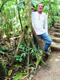
The guide also pointed out the "walking tree". It actually walks! From its trunk, it has a number of root stalks into the ground - kind of like an 8-legged stool. It sends out a new root or roots in the direction it wants to go. Then it then kills the root(s) from the other side and the whole tree moves, up to 2 meters a year! 


The early afternoon came with its typical threatening rain as we headed back into the Andes. The canyon route we took was known as the Route of the Waterfalls. Not long into the recesses of the mountains, the Amazon's moisture was blocked and we were saved from too much of a soaking. By late afternoon and after much twisting and turning blacktop behind us and after numerous tunnel passages, we came to a delightful area and town called Baños de Agua Santa. The town is a focal point for many eco activities. Being at the base of an active volcano, there are hikes with spectacular views of not only the volcano itself, but cascading rivers with rafting, zip-lines, etc.

Just outside of Baños, we rode a tram a couple hundred feet over the main river to the other side and then zip-lined back. There were 2 awesome waterfalls right under us. We had to hike up a bit and then zip-lined back on a different cable line over to the right of the tram.

2 waterfalls below the tram heading over to the other side

With afternoon light running out, we were sent to Baños town Centro and what a delightful surprise to find a charming colonial town nestled neatly between the steep cliffs. There was no lack of finding hotel space or restaurants, and once we checked in, we wandered the streets with bustling pedestrians and settled in a great little restaurant with some wonderful eastern cuisine. It also shows free movies every night in another room!

Accomplished 195 km today.

Saturday, October 22, 2011

Day 10: Wet laundry

We had breakfast at our hotel in Cotacachi Ecuador and then checked to see our line-dried laundry was ready. It was still not dry so we walked around the town some more and checked internet. Then as it was nearing 11:30 we decided to pack up anyway even though our laundry was still damp.

It was fairly cool out and started to sprinkle just a bit but then stopped right away. At first, the roads were not that enticing and we hit a few rough spots. Then we started to climb in elevation and the road became very winding. We ascended to 6,200 metres (that's 20,000 feet!) into the clouds of the Andes Mountains and then descended onto the other side of the Continental Divide, following river canyons, past waterfalls that cascaded in the jungle, and finally dropping into the Amazonian Basin.

Ruby at 4,000 m

Coming out of the Andes on the east (the Amazon side), we were met with an expansive vista of flat low laying land. It was striking how abrupt the transition was from near vertical to horizontal. It was as though the flatness that came over the horizon from the east was a green sea and its shores were the steep slopes of
the Andes. It reminded me of the scene on the east side of the Rockies, around Calgary AB in Canada.

We ran a baseline road southward to an elevation of only 420 m where we stayed at the small, clean, town of Tena. This woman was thrilled to have her photo taken at her fruit stand, and as we walked away, we could hear her giggling with another at a neighbouring stand.


From Cotacachi to Tena, we traversed 268 km.

Friday, October 21, 2011

Day 9: Cotacachi

After the bizarre foul-up at the Ecuador border yesterday, we decided not to return back to the border to be entered into the computer until after breakfast, thereby hopefully allowing time for their computers to be fixed. As we wandered around Tulcán, we took a photo of this mass of wires - what a way to spoil a window view!

Yikes!

There were a lot of indigenous folks dressed in their traditional outfits with the women wrapping their babies or young ones onto their backs. It still surprises me when I see how short in stature they are.

Full-grown adult indigenous women standing by a teenager

Thankfully when we arrived back at the border crossing, all the computers were up and running and the line-up was very short. We were quickly entered into the computers and had permission to pass.

As we travelled along the highway, Jordan notice an adventure motorcyclist stopped on the side of the road. He was riding a KLR 650, like our bike back home. So we stopped to say hello. He was a young man, alone, from Brazil travelling Colombia and Ecuador. He showed us photos of serious flooding that he came through in Colombia. We exchanged our boat card with his business card and his invitation to visit him in a few years when we sail past his home port.

We came to a fairly small town called Cotacachi early in the day but decided to stay. We found a Bed & Breakfast hotel with laundry service. We were told that there are no public clothes dryers in Cotacachi - just line drying. But we decided to take a chance that our clothes would be dry by morning.

While walking around town, we saw leather stores everywhere. We never noticed any locals wearing leather coats or jackets, and only a few carrying leather purses or wearing leather footwear, so their tourist trade and imports must be very high. Cotacachi is also a hangout for expats and intrepid travellers.

It's still been fairly cold at 2,400 m elevation. We travelled 165 km today from the border to Cotacachi.

Thursday, October 20, 2011

Day 8: Border closure

It was cold when we left Popayán Colombia this morning but as the day progressed it warmed up. The roads were not good and Jordan was constantly dodging potholes. We were held up several times by road construction crews (so the roads should be improved in the future). At one spot, the road work on a narrow mountainous section held up traffic for about 45 minutes. In the line-up and at the front (that's where motorcycles go to), we saw nervous military soldiers keeping a keen eye on things and casting apprehensive glances up in the jungles overhead.

Later, Jordan was reading in the Latin American section of the BBC news that there had been a surprise rebel attack on a military contingent not far from this point and where a dozen FARC guerrillas and 2 soldiers were killed.

Ruby's rear brakes pads were getting down to nothing and the front ones were also showing wear. Time for new ones but brake shoes for this brand of moto won't be available until we reach Ecuador. So Jordan was babying the rear brakes to preserve them.

Riding past steep cliffs on winding roads

We reached the border crossing and exited Colombia with no problem. And we also had a pleasant visit with 14 Chinese folks on an 80-day trip while we waited in line for our exit stamp. They were fascinated with the GoPro camera attached to Jordan's helmet and everyone wanted their picture taken with Jordan wearing his helmet. Cameras were clicking non-stop even though they had been told earlier to not take pictures in the Migration building!

We exited the Columbia Immigration, drove over the bridge, and were in Ecuador and at their Immigration. It was almost full! We were pointed to the end of the line. We noticed the line wasn't moving and the lone officer behind the window wasn't processing anyone. Shortly after we arrived, they were not letting anyone else inside. We were told that their computers were not working and it was the third time this month. Everything was at a standstill. No one could be processed either for exiting or entry to Ecuador.

Finally after about 4 hours, the officials stated if they were presented with photocopies of specific pages of passports, they could issue temporary entrance into or exit from Ecuador, and in which case people would have to return the next morning to be entered into the computer. So there was a mad dash for the door to get to nearby copiers!

With our required copies, we got our temporary stamp and in the dark headed up the road to a nearby motel. What a day after 321 km from Popayán Colombia to nearby Tulcán Ecuador!

Wednesday, October 19, 2011

Day 7: Headin' south


We left Jorge's finca in Colombia today under cloudy skies as we had decided it was time to start heading south and for hopefully less rain. Unfortunately, the weather never co-operated for us to swim in the backyard pool and we never worked up enough nerve to ride Jorge's beautiful horse.

On our way to Popayán, we passed by a couple of flooded fields. We also saw news reports of landslides and closed roads. Apparently October had 16 days of record rainfalls and we were leaving just in time!

We enjoyed a dry ride but it started to rain just after our arrival once again in Popayán Colombia. On our way through Popayán the first time, we missed the best part of it. This time, meandering the streets for a nice hotel, we came to Old Town, a quaint colonial section. Here we checked into Hotel Colonial and then did an evening stroll and fine dined at an Italian restaurant in the town's charming atmosphere.

Purchasing alcohol is a little different than in Canada. Here, it is behind locked gates. From outside, you pay through the locked gate and then they pass the alcohol through to you on the street. No wandering around looking at bottles and prices...


We covered 307 km today.

Tuesday, October 18, 2011

Day 6: Salento sortie

It had been recommended that we check out a not too distant town called Salento, so with cloudy skies and rain gear, we headed out from Jorge's finca. Unfortunately, shortly after arriving, it started to pour earlier than usual. It's the rainy season. Salento is off the main highway connected by a picturesque winding drive down a valley and back up the other side. The little town is perched on a ridge with views to the distant green rolling hills. But it was a quiet, relaxed, cool little town with its colonial style - but different from typical colonial towns in that many of its structures were a wood-framed type of architecture.

We stopped for coffee that was made using this coffee machine that's over 100 years old...


Because of the rain, we were not able to continue on to the hot springs with a waterfall that we had been told about and had really been looking forward to swimming there.

Back at the farm, we dried our clothes over the oven that was cooking macadamia nuts. We had been wearing rain gear but I guess travelling 80 to 90 km per hour in the pouring rain...

Monday, October 17, 2011

Day 5: The finca scene

We had time for a walk through some of Marta's property at Casa Jardin Zen (Armenia Colombia) before leaving. During the last 20 years, Marta has turned her sloping hillside below her home/guesthouse into a veritable jungle by planting virtually everything that we saw. It was like wandering along trails cut in a natural jungle. It was hard to believe that she had actually planted it all herself.


 Jordan hiking past hundreds of bamboo trees...

Santiago (Jorge's helper), came to escort us to our next destination of "Betica". Jorge, our Colombian friend, owns "Betica" which is a finca (farm). There Jorge grows macadamia nuts and coffee beans. He also rents land to another who grows papayas by the thousands. From the macadamia nuts, Jorge also creates a spread like peanut butter only it is crunchy macadamia butter and so delicious.

Macadamia nuts & coffee beans drying - roof is pulled overtop when it rains

The coffee from his beans is the best we've ever tasted, not surprising though as we were in the heart of the Colombian coffee country. They call this prime coffee growing area the Coffee Triangle as it sits between the major cities of Bogotá, Cali, and Medellín.

 Jordan raking coffee beans

We could walk outside and pick mandarin-type oranges to eat from his tree or fallen macadamia nuts from the ground. What a delightful treat. Jorge also processes honey that his bees make from the macadamia pollen.

As it was early in the day, we decided to check out the famous Parque Nacional del Café. This is not a cafe but a famous park area with amusement rides, museums, eco-areas, and of course coffee shops/restaurants with delicious Colombian coffee. I've even started to drink coffee again!

We were just entering the building to watch a performance when it started to rain. It was a great show with very colourful costumes but when the show ended, it was pouring and did not look like it was about to let up. We had not taken any rain gear with us so we had to ride back to the finca on Ruby and were soaked though and through upon arrival.

Sunday, October 16, 2011

Day 4: Casa Jardin Zen

We travelled from Popayán Colombia to near Armenia, also in Colombia. We passed by a lot of places making bricks and noticed many of the numerous sugarcane fields being harvested. Upon stopping at a fruit and veggie stand, we purchased 4 sapote after sampling. This is a very stringy but mildly delicious fruit.

There are motorcycles travelling everywhere, most carrying all sorts of cargo. Chickens. Produce. Big milk cans. Sometimes as many as 4 or 5 people on 1 bike. We even saw a girl with her dog perched on her lap.

Ecuadorian panniers!

Once we arrived in Armenia, we were having a hard time finding Casa Jardin Zen (http://www.casajardinzen.com) which was highly recommended to us by a Colombian boater friend whose sister, Marta, owns it. We stopped and asked a parked motorcyclist is if he knew where a very popular disco was (which is very close to the Casa) and, as he did, he said "follow me" and away we went on his tail, through the late day's rush hour traffic. Upon arriving at the closed disco, he then called Marta on his cell for us. Without delay, she appeared from behind all the greenery which was hiding her fabulous property from the road. We thanked our escort and then followed Marta inside.

Casa Jardin Zen

We had a great visit with Marta as she showed us around her eclectic place. After being shown to our room, we watched the hummingbirds as they flitted around the beautiful red flowering tree beneath the window. Marta was busy preparing for a biker group arriving the next day for an event. She was hanging pictures of motorcycles, jerseys, helmets, and even an actual motorcycle parked inside. We retired early after an exhausting day, letting Marta finish with her preparations.

On our route, we passed through large and small towns including Palmira, Buga, Tuluá, and Bugalagrande. We made 291 km today through beautiful scenery.

Saturday, October 15, 2011

Day 3: COLOMBIA

We left the outskirts of Tulcán Ecuador bright and early at 07:00 this morning. It was pretty cold out being on a motorcycle with an elevation was 2,950 m but we were dressed warm and we crossed into Colombia at Rumichaca with no problems. (Rumichaca is shared by both Ecuador and Colombia.) We would now be using Colombian pesos instead of the US dollar.

Welcome to Colombia

As we rode through Ipiales just over the border, we noticed a Colombian essence. Many were using a different type of horse cart to carry their wares, with 1 man sporting a bright and happy smile as he trotted along in his cart. Woollen ponchos were a very popular covering for warmth and have been used since pre-Hispanic times by peoples of the Andes.

From the high plateau of Ipiales, the Pan-American Highway soon dropped us into a verdant green gorge on a thrilling twisting and turning road. The lush hills and valleys seemed to be sectioned for farming and were quilted in greens and browns - grasses, crops? We also saw so many cascading waterfalls, with 1 falling from the high top of the mountain, flowing under the road that was cut in the steep slopes, and then continuing way down into the valley below us. It was the longest flowing waterfall we have every seen!

This is 1 very long waterfall!

Roadside security checks have been numerous. We were almost always waved through with a smile and a thumbs up. When we were stopped and checked, we were always dealt with in a friendly manner.

We've noticed mega motorcycles in Colombia - individuals as well as groups. We talked to a group of about 15 BMW adventure riders travelling from Alaska to the southern tip of South America. They were from all over - Europe, Canada, US. Tolls are free all throughout Colombia for motorcycle riders. But in some of the mountainous areas, the roads were pretty bad - full of potholes - particularly from Pasto to Popayán but the spectacular scenery more than made up for it, some of the most dramatic we have seen.

We travelled 316 km today and stayed in Popayán which is rich in colonial architecture and has a historic downtown. It is also known as Ciudad Blanco, the white city, as most of its buildings in the old section are white.

Friday, October 14, 2011

Day 2: Almost at the border

Early in the morning at 03:00 in our Santa Domingo hotel, we were awoken by loud knocks on our door by someone demanding "Documento". There was no peep hole in the hotel door and Jordan was feeling a little apprehensive, so he stashed our cash and then answered the door. The National Police were there wanting to see identification (passports) which he showed them. During the exchange and in their rapid Spanish they were asking for something. Jordan recognized enough to believe that they were asking for some kind of propina (meaning a tip) but Jordan just played dumb and responded "no comprendo" (meaning I do not understand). And then they continued from door to door, waking up everyone in the hotel.

Jordan later mentioned that he had been on the verge of telling them that this type of intrusion wasn't appreciated but after was glad that he bit his tongue. They were performing a just function. Jordan had recently read something that Ecuador, being between the Peruvian and Columbian drug producing areas, had evidence of the presence of the Mexican Sinaloa drug personnel, so figured the National Police were doing a standard door-to-door check in this crossroads city (and of course, as an afterthought, seeing gringos, decided to also ask for propina).

At a fruit and veggie store the next morning in another town called Otavalo, Jordan found this large papaya...


At one point it was getting to be lunch time when we noticed a few trucks stopped outside a little kitchen next to a small waterfall. Truckers usually know the good spots. It was mostly meat on the menu so we asked for fried rice mixed with tomatoes and onions. For 2 large servings and 2 fresh juices, it was only $2.60. Food is so inexpensive in Ecuador.

We have discovered that guinea pigs originated in the Andes Mountains and are commonly used for food in South America. We don't ever intend on tasting it (even if we weren't vegetarian) as we can't help thinking of them as pets as in North America.

We went through 4 road checks where we were asked for driver's licence and/or motorcycle papers. At one stop, our check was interrupted when the cop looked way up the road and quickly handed back our papers and jumped in his vehicle and rushed off after someone who had done a U-turn to avoid the check. They not only look for proper papers and registration, but no doubt are looking for illegals.

As we climbed the Andes Mountains, from high above on the highway, we were looking down upon a sea of bamboo groves with their beautiful lime green wispy foliage whispering in the light breeze.

We crossed through Pifo today and travelled 358 km, passing well clear of Quito and through colonial Otavalo, spending the night 7 km from the Colombian border on the outskirts of Tulcán.

Thursday, October 13, 2011

Day 1: To Colombia by moto

We left Puerto Amistad at Bahía de Caráquez (Ecuador) on our motorcycle Ruby today with a northern destination of Armenia which is about half way up into Colombia. We decided to try a different route than when we headed to Quito Ecuador in August as the road was not very good for the first few kilometres. But what a mistake that was! The "road" we took this time was atrocious, if you could even call it a road.

It started out winding and good but then for about an hour we rode slowly over large rocks, through big ruts and over large humps, and past little pueblos that were on the banks of the river delta. We passed a man on a motorcycle whose passenger was holding, by their skinny legs, live turkeys in 1 hand and live chickens in the other hand as they lifted up their heads and gawked all around!

The houses were very destitute in this area and garbage was strewn in the ditches. And many residences had self-made topes (speed bumps). Why is a mystery as no one could travel fast on this road!

As we continued towards Flavio Alfaro, there were piles of oranges disposed in the ditches. I guess the locals just had too many and/or couldn't sell them - a shame to see such waste.

Meat for sale by this expressive gentleman on the street in Flavio - including a cow's head on the bottom shelf of his stand...


Other locals along our journey decided to use a length of the highway shoulder to dry their beans. What kind? Not sure. But with dirt yards, the highway makes a nice flat, hot area for drying. In some areas, the highway is built super close to some residences. One step out their door and they are literally on the highway - never in Canada!

There is so much bamboo in Ecuador. We've seen it used for decorative purposes, furniture, fences, structural components, and even the entire home. Some of the homes built by individuals for their own use are very sad looking with wide gaps between the bamboo pieces and no doors and/or windows other than perhaps a piece of cloth. Many of them are built on stilts high off the ground in case of flooding. In other areas, where trees were abundant, it seemed the custom to use wood planking for all parts of their structure. I noticed a house with a door (no stilts) but I can only imagine what would skulk in beneath the 4 to 6 inch gap between the bottom of the door and the floor.

We stayed overnight in Santa Domingo, at the base of the Andes and about two thirds the way to Quito, for a total of 191 km on our first day.

Sunday, October 02, 2011

San Clemente

On a beautiful day, we decided to take a respite from boat jobs and take Ruby, our iron pony (motorcycle), out for a run. Jordan found a road that led down to the beach, and as the sand was firmly packed, we opened the throttle and blasted along the beach. We ended up going for miles enjoying the scenery with the cliffs on our left, emerald green sea with its crashing surf on our right, and flecks of skittering little crabs making haste to their protective sand holes.

We finally came upon the tiny village of San Clemente (Ecuador) that had a country road flanking behind it. The incoming tide prohibited us from making the return trip back up the beach, so we used the winding road to go all the way back to Puerto Amistad at Bahía de Caráquez, about 28 km away.

The beach ride had been so much more enjoyable and scenic than the highway ride.