Sunday, March 31, 2019

Puerto Rico delights

Sea Turtle found several interesting one-night anchorages, such as the delightful island of Isla Ramos where we were the lone explorers. It evidently had no permanent inhabitants though we saw chickens in a cage and a wondering Siamese cat that we watered. We retrieved a couple of coconuts and found a few good shells as we combed the beach. Thankfully a local boater soon arrived to tend to his animals.

The next stop was by the large mangrove basin of Punta Medio Mundo that we explored in the dinghy. We had good fun zooming through the labyrinth of channels and even managed to get lost a couple of times in the natural maze!

Mangrove network

Click here, Mangrove Mania, to watch our 35-second YouTube video of speeding through the mangroves.

Later in the day, we moved to a cove on Isla Pineros and picked up a mooring buoy in front of a beautiful beach. There were a couple of other boats there but they soon left and so, again, we had the place to ourselves. It would have been a perfect stop other than we were restricted to the beach due to the potential danger of unexploded ordinances, the remnants of past military exercises there.

The other deterrent was the onslaught of biting no-see-um bugs. (Hmm, maybe that's why the other boats left.) Wearing only a bathing suit, I was a bug buffet and was in agony with the itch of the bites covering my body. Jordan escaped the torture as he had worn a long-sleeved shirt.

No man's land

We next anchored at Cayos de Barco in the lee of its string of small mangrove islands that formed a barrier against the open ocean waves.

Another overnight stop was at Isla Muertos whose name means death or coffin. The Island is a marine park that's sensitive to sea turtle nesting. There are no permanent residents and it's a popular place for day boaters from the mainland a few kilometres away.

We walked a fair distance from our dinghy along a cactus lined trail until we got to the base of a hill, and from there, the trail got steep and gnarly as we climbed to the top. On top was an old large lighthouse building that obviously housed a contingent of caretakers and protectors of the realm. It had long since been abandoned and the only function now is a small high intensity beacon light for today's seafarers.

Lighting the way

We discovered an opening in the wall that we could climb through to get to the spiral stairs that led up to the top of the lighthouse tower. It was a nerve wracking 50-step climb on rusty stairs, but the awesome view was worth it.

A lighthouse vista

The rusty stairs weren't the worst scare of the day though. What was terrifying was the snake that wrapped itself around my leg - not once but twice!! The first time, I kicked it off but it immediately wrapped itself around again. Screaming and kicking finally shook it loose and away but not before I tumbled in the frantic effort. Phew! Time to leave Muertos...

Anchorages:
N18°18.929' W065°36.743' Mar 27 Isla Ramos
N18°15.768' W065°36.567' Mar 27 Punta Medio Mundo
N18°15.297' W065°35.312' Mar 28 Isla Pineros
N17°55.084' W066°13.998' Mar 29 Cayos de Barco
N17°53.555' W066°31.695' Mar 30 Isla Muertos

Wednesday, March 27, 2019

PUERTO RICO

So it was on to a new country after leaving the British Virgin Islands, or should we say a new territory. Puerto Rico has been a territory of the US since they defeated Spain in the Spanish-American War of 1898. There is still a Spanish feel here and they have maintained their language in all aspects of life.

Coming from the Virgins, the first point of land in Puerto Rico was Isla Culebra. There it was immediately evident that we had left the charter fleets behind and the boaters were generally of the real cruising kind. We dropped anchor in the large bay and went ashore to complete our official check in which required a nice 1.5 km (1 mi) walk to the Customs office at the little airport.

Multi-coloured sights of Culebra town

The lone Custom officer's demeanor suddenly changed when we noted we had a cat on board. She went from being officiously pleasant to an outright exuberance, as though we were long lost relatives by virtue of feline commonality. I'm sorry, she said, but MY babies are the most beautiful cats in the world (she has 2). So out came the smart phones and we shared kitty pics. Not your typical US first line of empirical defense. Secret to bad guys: Enter this port with a kitty!

We wanted to visit Flamenco Beach, about 4.5 km (3 mi) out of town, which boasts being a top beach of the world. We tried to rent a golf cart, a popular means of getting around, but all were booked; it was a holiday weekend. So in the heat of the day, we started to walk and before long hitched a ride. It was definitely a beautiful beach, obviously an opinion that was shared by many - it was packed.

Flamenco Beach

Back at our anchorage, The Dinghy Dock Bar & Grill was THE place for boaters (and huge tarpon fish!) to hang out. At water's edge, it had recently received a new facelift after being beat up by Hurricane Maria of 2017.

A good metre in length

From there, we travelled a few hours west to a small island right offshore from the main big island of Puerto Rico. There we left Sea Turtle for the day at a badly damaged marina while we rented a car to view some sights on the main island that we accessed via the marina's free water taxi.

We first drove northwards to San Juan and through its modern sprawl to Old San Juan, its quaint old town section where the architecture of the buildings and the fort were most impressive, as well as the sinking blue ceramic cobblestone streets.

One of many

Pretty in pink

Pretty in blue

Old San Juan was the strategic base for centuries where events of the European occupation played out. There we toured the well preserved El Morro Fort that sits prominently on the point and where it protected the harbour.

Lounging lizard at fort

Guarding harbour entrance

For a complete change of pace and scenery, we spent the latter part of the day in the mountains as we drove a serpentine narrow road up into the rainforest of El Yunque park.  The waterfall was minimal due to lack of rain but we enjoyed distant views from a geographical high point and had a delightful picnic in nature's splendor before returning to Sea Turtle.

Park picnic

Anchorages;
N18°18.414' W065°17.837' Mar 22 Culebra (Ensenada Honda)
N18°20.218' W065°37.303' Mar 24 Isleta Marina (island)
N18°20.331' W065°37.270' Mar 25 Isleta Marina (marina)
N18°20.234' W065°37.301' Mar 26 Isleta Marina (island)

Thursday, March 21, 2019

British Virgin Islands exit

Still in the British Virgin Islands, we checked out Peter Island as we sailed past and seeing no inviting anchorages continued a bit farther to Norman at Privateer Bay. This island, and the caves we snorkelled, was what some believe was the inspiration for Robert Louis Stevenson's Treasure Island novel. The treasure we found was the glassy clear waters and numerous fish.

Cave entrance

A bit of red sponge on cave walls

3-foot barracuda cruising by

Snorkelling in the Caribbean so far has been in pretty clear waters, sometimes up to 15-m (50-ft) visibility. From our experiences though, we were disenchanted in the lack of sea life beneath the surface. The coral was pallid and paltry and equally disappointing was the lack of abundant and varied fish life. The other surprise was, for us, the inexplicable absence of dolphins. What was encouraging to see however were plenty of sea turtles!

An unexpected visitor swimming beneath Sea Turtle, a sleek sting ray carousing with fish friends, was spotted by Jordan.

A ray and his buddy

Our last BVI stop was at Road Harbour on the main Island of Tortola, anchoring in a tight cove of small marinas and numerous shipwrecked yachts left from Irma. The photo below shows salvage efforts to raise this Irma casualty...

Water being pumped out

We pulled into the fuel dock just as Sir Richard Branson was doing the same in his runabout. He offered a pleasant greeting and a brief chat about his development on Mosquito Island.

After fuel fill-up, was an overnight moorage without going ashore at Saint John of the US Virgin Islands where we would depart for Puerto Rico the next morning.

Anchorages:
N18°18.659' W064°37.615' Mar 18 BVI Norman (Privateer Bay)
N18°25.518' W064°36.973' Mar 20 BVI Tortola (Road Harbour)
N18°21.268' W064°45.535' Mar 21 USVI Saint John (Cinnamon Bay)

Sunday, March 17, 2019

More British Virgin Islands

Continuing in the British Virgin Islands, we headed to the northeast end of Virgin Gorda Island, sailing past two islands that are owned by the famous billionaire Sir Richard Branson known for his Virgin Group empire (records, airline, cell phones, space); he was knighted for his entrepreneurship.

His islands are Necker and the most recently acquired and undergoing development of Mosquito, the latter almost connected to Virgin Gorda.

Branson's Necker Island

We found a quiet beachfront spot to anchor in the lee of Prickly Pear Island in the large well-protected sound. Every time we anchor, small fish find shade and protection under our hull but here we were surprised to see a large remora, at least a metre long, in the school. We coaxed him out with crackers for a snapshot. Note the flat suction section on top of its head that he uses to attach himself for free rides on boats or larger fish.

Remora

We dinghied around the bay to see how Irma affected these parts. Apparently they took a direct hit and it showed. However the BVIs seemed to have responded quickly and new buildings are going up, some already completed and in business, such was the case when we stopped at Leverick Bay on the Virgin Gorda side of the bay where we enjoyed rum punches.

Leverick Bay

Another perfect evening was spent alone when we picnicked on the beach at Prickly Pear where, by the lambent flames of our campfire, we watched the sun set and barbecued our veggie burgers. We took Chanty along, to her objection, however as the daylight faded she felt more secure and at ease.

Beach barbecue

On the move again, we sailed a few miles in the warm trade winds to the southwest end of Virgin Gorda with a frisson of excitement to see the Baths, a most popular and unusual natural setting. The Baths are granite boulders stacked along the sandy shore, as though some fairy tale giant placed them perfectly to allow passageways in, around, and under them and where the emerald waters washed through creating sea pools. You are not allowed to take your dinghy ashore so this required securing it to a buoy line about 100 meters out and swimming to shore.

Lost in the Baths

We left in the afternoon for the next, Cooper Island. The only anchorage there is very deep and filled with mooring balls which were all either occupied or reserved. We picked a spot to anchor on the perimeter and ran a stern line ashore to try to hold us in place and avoid the catamaran moored close by.

Cooper Island sunset

But returning to Sea Turtle at sunset, we discovered a line was led from the catamaran to Sea Turtle with a few dinghies around it. The convolution of winds and tides had made it a less than ideal situation putting us dangerously close to rocks on shore and the catamaran was endeavouring to prevent that.

We quickly boarded, thanking them as we moved to a more secure, yet deep anchorage at the other end of the pack. This had not been our defining moment of anchoring. It was payback time for the times Jordan had rescued inexperienced boaters in the Med that yielded us bottles of wine for our help. So later, we delivered a bottle of gratitude to the catamaran.

More BVI anchorages:
N18°30.278' W064°22.318' Mar 15 Prickly Pear
N18°26.345' W064°26.690' Mar 17 Virgin Gorda (Big Trunk Bay)
N18°22.932' W064°30.983' Mar 17 Cooper (Manchioneel Bay)

Thursday, March 14, 2019

British Virgin Islands

Our pre-approval to arrive with our pet Chanty in the British Virgin Islands (BVIs) was considered tentative, subject to the review by the official vet awaiting us at the check-in port of Soper's Hole on the Island of Tortola.

We had heard stories of over officious BVI officials, so arrival wasn't without a slight bit of anxiety. However that worry quickly evaporated when the friendly vet did a cursory review of Chanty's paperwork and gave us an "all clear". Actually, all the officials were very friendly and efficient.

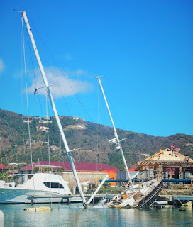
Once again we saw evidence of 2017 Hurricane Irma that laid waste to so many of the Caribbean islands. There were broken or missing docks, some roofless homes and businesses still closed and others under repair or reconstruction, and boats left broken and/or high and dry.

Demo derby

The next morning we loosened the reins from the mooring ball and motor-sailed to the nearby Island of Jost Van Dyke and the popular White Bay, anchoring early behind the reef and close to the brilliant white sand beach. As the sun grew higher, more boats arrived and mono hulls (2 of us) were soon outnumbered by catamarans, a good many of them motor cats (no sailing configuration). The beach bars soon became filled with daytrippers shuttled over in open speed boats.

Different cats

Bathed in warm sunshine, we walked the sand beach and snorkelled in the crystal clear, sapphire blue waters, seeing some coloured fish but little coral of good quality.

Sun, sand, and sea

Disappointing coral

In an adjacent bay, a short dinghy ride away for us, we found the infamous Foxy's. Foxy and his beach bar and restaurant has been a fixture there for years and made popular his Caribbean hospitality and guitar strumming serenades to his patrons. By the merits of his contributions to tourism, he was knighted by the Queen of England.

Entertaining Foxy

Then it was back to Tortola for a brief stop at Cane Garden Bay. There we suffered the high cost of a taxi up the steep slopes and down to Road Town, the capitol of Tortola, to get our internet fixed (for our internet fix!)

Cane Garden Bay

Then for a more secluded and peaceful stop, we motor-sailed a short distance eastward to Guana Island anchoring by the pristine sand beach of White Bay and did a lucklustre snorkel at Monkey Point.

The closing of a day is hard to beat when we watch the sun sink below the sea, unimpeded by boats, islands, or clouds. Relaxed in our cockpit, we watched as the fiery orb died with a hint of a green flash, acknowledged by some faint cheers of nearby boats. The encore as the curtain fell was a sky of silky colours. Reds on the horizon seamlessly transformed to pinks then to a charcoal blue infiltrating the night sky above.

British Virgin Island anchorages:
N18°23.203' W064°42.115' Mar 11 Tortola (Soper's Hole)
N18°26.502' W064°25.821' Mar 12 Jost Van Dyke (White Bay)
N18°25.597' W064°39.709' Mar 13 Tortola (Cane Garden Bay)
N18°27.841' W064°34.257' Mar 14 Guana (Monkey Point)
N18°28.226' W064°34.473' Mar 14 Guana (White Bay)

Monday, March 11, 2019

US Virgin Islands

After a delightful visit with old friends and exploring Saint Martin/Sint Maarten of the Caribbean, we were off to the Virgin Islands.

Two sovereigns claim the chain of Virgin Islands, the US (USVI) and Britain (BVI) and we would visit both, the first being the USVIs. We anchored in the harbour of the busy port of Charlotte Amalie on the Island of Saint Thomas, a convenient place for a number of chores and purchases needed.

Waterfront

Our first stop (after official check in) was to purchase a SIM card for our smart phone with a data package so that we could be connected to the world again. The second stop was the optometrist for the much needed new glasses for Jordan. He had broken his a couple of months ago, and had since been wearing them with a nerd worthy repair job. This was the first time we would be in one spot long enough for the wait time to have them done.

This spot was more popular to the ubiquitous cruiseship crowds than the cruising sailor, but we found some pleasant aspects that made our time there drift by with ease.

Another type of cruising

To get around, we made good use of the abundant Safari trucks with cheap fares and friendly riders always helpful with directions. One trip was to Brewer's Beach with a picnic lunch where we spent the day.

Safari bus

We hit it off with a US couple on a boat next to us who spends half their time here and half their time back home in Montana. We shared company in one another's cockpits and a lobster dinner at a great restaurant that overlooked the harbour.

Lobster affair

We strolled the alleys of the older part of town where old shipping warehouses have been turned into a plethora of jewellery stores, souvenier shops, and eateries that siphon in the cruiseship herds. At one cafe at Creques Alley while sipping iced cappuccinos, we were told that this is where the singing group, The Mamas and Papas, hung out and got their start jamming to the locals at the time.

Charlotte Amalie side street

Side view of Bumpa's Restaurant on bright waterfront street

With new glasses perched on his nose, it was time to head over to the British Virgins. But first, we had to apply for a pet permit from the Brits for Chanty, out cat, a not so easy task that required a US vet inspection and official paperwork sent for approval ahead of our arrival there. Wisely we had always kept current with the most important vaccinations and tests.

Once that last chore was done, we did the official US checking out and pulled anchor for a 2-hour beat up the coast to spend the night anchored in Christmas Cove in the lee of Great Saint James, a small private island (165 acres).

USVI Anchorages:
N18°20.279' W064°55.898' Feb 24 St. Thomas (Charlotte Amalie)
N18°18.468' W064°50.031' Mar 10 Great St. James (Christmas Cove)