Wednesday, September 29, 2010

Train to Creel?

Getting closer to our destination of Copper Canyon Mexico...we made small repairs to the bikes in the morning and left Chinipas around 10:30 to head for Temoris (N27°16.284' W108°16.329'). When we arrived, we watched the on-going rodeo as we ate lunch. We had been told that we could catch the train to Creel from here; we were all feeling the need for a break.

But of course upon arriving in Temoris, we were then told that we could travel as passengers on one train but the motorcycles would have to travel as freight on another train. As we were not willing to send the bikes without supervision, apprehensively we decided to continue by bike to Creel. Well the roads started to improve and part way there, we finally came upon a PAVED road!!! Who would have ever thought that we would be this happy to finally see a paved road...

A big kiss for smooth pavement!

Soon we came to Divisadero in Chihuahua (N27°32.042' W107°49.223'), a train stop on the rim of Copper Canyon and a short distance from Creel. Here, the indigenous Raramuri dress in brightly coloured apparel selling their exquisite hand-woven baskets set up around the area. Divisadero has one of the best panoramic views of the Canyon at an elevation of 2,230 m above sea level with a view of over 100 miles.

Copper Canyon is composed of 20 canyons that in total are 4 times larger than the Grand Canyon, and in some areas, deeper. We found out later that within a week a new tram is to open that takes visitors to the bottom of Copper Canyon.

We continued on to Creel (N27°45.037' W107°38.034') where we were encouraged by different hotel owners to stay at each of their hotels - the town seemed to be presently hurting for business. There was an English speaking tour guide in town who provided us with a lot of info. After good food and a restful sleep, we left with clean laundry and smiling faces.

Indigenous Raramuri in Creel

Monday, September 27, 2010

Where is Chinipas?

I digress. When planning the Copper Canyon motorcycle trip, Jordan would go on Google Earth and get excited about the serpentine roads he saw indicating adventurous mountainous travel - be careful what you wish for!

From Álamos, we headed back to Los Tanques where we were instructed to go to Milpillas and then to Chinipas. Upon arriving at Milpillas (N27°12.500' W108°36.030'), we were then instructed that we had to return to Los Tanques and go a different direction to Chinicas (not Milpillas) and then to Chinipas.

We came upon a donkey on the side of the road where we had stopped for a brief rest. He seemed to be a bit friendly, not like on our previous motorcycle trip where you could not get close to the donkeys. So being Jordan, he decided to see if he could sit on him, and...


...success, the donkey did not seem to mind at all!

On the way, it started to rain which of course made the roads slippery. We came to another water crossing and had to swerve to avoid a large deep pothole. The bike slipped once again and Jordan's foot went into deep water, soaking it completely.

Jordan wringing out his slopping wet sock

We followed a truck part way but needed a break for snacks as we had not eaten since early morning (carry snacks - restaurants are in short supply!) We seemed to be doing okay but couldn't find Chinipas. We decided to turn around and then found the "sign" - Chinipas was carved into a rock on the side of the road! "Road" is an overstatement. These roads were narrow, axle busting, extremely steep at times, and switchbacked with sheer drop-offs. Hey, but the scenery was starting to get spectacular.

Through the heavy rain and clouds, we spotted Chinipas (N27°23.313' W108°31.599') in the valley far below - but first we had to cross a deep fast-moving river. Where was the bridge? Two young lads were playing in the river and pointed that a bridge was "up and around, just follow the road". Oh no! Each slick muddy road (Aaron and Dee dumped a couple of times!) had numerous turn-offs. After several attempts, Jordan finally found the bridge.

Several boys on a quad led us to a motel just at dusk. We were beat and slopping wet and the bikes caked in mud. After cleaning up and drying off, we hit the restaurant where we were finally able to have a meal instead of just snacks. There had been no restaurants between Álamos and Chinipas along the route that we took.

So far, 5 motorcycle spills for us, 4 for Aaron and Dee - these mountain roads are a real mishmash of surface types.

Adventurous day

Today was a very adventurous day as Jordan and I and his son Aaron and gal Dee continued towards the Copper Canyon in Mexico. We left the bustling metropolis of Obregón Mexico heading inland on a somewhat direct but less travelled route to the Copper Canyon (rural would be an understatement).

That day we hit roads that were hard-packed dirt, sandy, loose gravel, muddy, white-knuckle, and even a section of hand-laid cobblestones which was very beautiful but hard to control motorcycles on. I experienced my first ever spill. We came upon a concrete river crossing (one of many that we would cross) that was overflowing with a few inches of fast-moving river water. As we proceeded across, the slick algae surface caused the bike tires to slip out from under it. Before we knew it, we were sliding through the water.

Getting up after slipping - all wet - but saved the camera!

Very minor spill but we were both wet and Jordan pulled a muscle. A few hours later, Aaron and Dee slipped on a duplicate crossing and were then wet too!

The map indicated we were heading towards Quiriego and San Bernardo, also in Sonora. Needless to say, there was a great shortage of signs and the road was several hours longer than indicated. We appeared to be lost but the guys always figured it out with somewhat different directions from different locals in small villages. When we finally found San Bernardo (N27°24.078' W108°50.441'), we purchased some snacks as we had not come across any restaurants.

Buying gasoline was always difficult to find - once we were simply instructed to go to Rafael's house (no signs of course) where the motorcycles were filled from small plastic jugs along with great conversation. The next time, the gas pump was hidden inside a small white building!

Buying gas at Rafael's house

Throughout the day, we travelled through exceptionally lush green valleys where butterflies were everywhere and several mountain areas were covered with golden flowers.

The heat was stifling so we stopped for a breather in the shade at Tanques La Higuera (Los Tanques) (N27°12.409' W108°53.370') where Aaron discovered that his pelican bag rack (luggage rack) was falling off from all the shaking on rough roads and needed to be re-welded. The shop was closed and we had to roust the owner from his Sunday dinner to get the job done. While the guys were getting the welding done, Dee and I were entertained by the jovial locals who were enjoying a beer where we sat outside by a store.

Kindly man welding Aaron's motorcycle rack at Los Tanques

As it was getting close to sundown, it was suggested that we backtrack 26 km to Alamos (N27°01.397' W108°56.229'), where hotels were available. We didn't cover much distance but we ended up in this town that was not on our route but was a real joy to find. A very quaint, old colonial-type of town with fabulous architecture and a busy town square.

Alamos - a great find

Sunday, September 26, 2010

Grand Canyon USA

Continuing our road trip from Victoria BC back to Sea Turtle in Mexico, our next stop was a day at the Grand Canyon (N36°06.523' W113°14.239') in Arizona, a first for me and Dee. We had originally wanted to walk out on the glass floor where you can look down into the Canyon for a great view, but we discovered that the glass floor was at the west end but the south rim has preferred views. Got several great shots and stayed until the sun set. Many more in the Photo Gallery (click on Copper Canyon Trip once in the Gallery). Made it to Prescott Arizona that night.

Jordan and Judy above the Grand Canyon

The multi-layers of the amazing Grand Canyon

Visited with our good friends near Palm Springs California (N33°53.122' W116°55.350') who had been storing our motorcycle for us. After some quick services, we would ride the bike to Sea Turtle with Aaron and Dee following in Aaron's truck. On the way, we drove through some sweltering temperatures. Heat rose to 42°C (108°F). Before crossing into Mexico, we stayed the night at Jordan's sister's vacation cottage in Yuma Arizona (N32°40.088' W114°36.118').

The border crossing was quick where we got a 180-day Visa. No questions asked about supplies, and we were on our way. After about 4 hours of riding, I felt like I had heatstroke or was badly dehydrated; we got a revival break in an air-conditioned restaurant with a meal and refreshing drinks.

After a one-night stay at Santa Ana (N28°23.099' W109°08.543'), we finally made it into Marina Seca at San Carlos (N27°57.230' W111°03.060') for a quick check on our boat where all appeared well. At the boat, we wasted no time. Aaron unloaded his motorcycle, left his truck at the Marina with Sea Turtle, and we continued out on both motorcycles heading for the Barranca del Cobre (Copper Canyon) in Chihuahua. We stayed at Obregón (N27°29.122' W109°56.370') about 125 km SE of San Carlos  where we thoroughly enjoyed the motel swimming pool to escape the heat and where it POURED rain unbelievably during the night, but the next morning, it was back to sizzling heat.

Tuesday, September 21, 2010

Heading south

We left rainy Victoria and did a lot a steady driving with Jordan's son Aaron and gal Dee in Aaron's truck to head back to San Carlos (in Sonora Mexico) to take our new purchases and supplies to Sea Turtle and then do some exploring.

On the way down, we stopped at Reno Nevada (N39°39.385' W119°53.125') to watch the annual air races on Sunday. A lot of beautiful planes, first-rate races, and some great air displays too.

A "Rare Bear" plane

The Canadian Snowbirds put on an outstanding performance to the delight of the audience...


Unfortunately, there were 2 incidents: a plane crashed during the second last race where the pilot walked away with cuts and bruises but destroyed his plane, and the much awaited final race did not come to fruition as officials deemed that the wind was too strong to have a safe race. The guys were real disappointed, but safety first.


That night we stayed at a small town called Tonopah (N38°04.175' W117°14.019') about 3 hours before Las Vegas in the Clown Motel. Very weird - there were literally clowns everywhere - on each motel door, pictures in the rooms, a lobby totally filled with clowns - but the parking lot was highly lit so we felt Aaron's motorcycle in the back of the truck would be secure (ours is in Palm Springs Arizona). Tonopah has an interesting, very old, entirely wooden cemetery:

1901 - 1911

Just before Vegas, we made a small detour up to the state park on Mt. Charleston (N36°15.271' W115°38.450') where surprisingly there is a pine forest, vacation homes, and even a ski hill. After a quick drive down the Strip (Dee's first time), we headed east over Hoover Dam (N36°00.490' W114°44.350') where we saw the spectacular new arching bypass bridge that spans over the Dam and the Colorado River. Check out the amazing construction details on Google.

New bridge over the old

From there, we made it to Williams Arizona (N35°15.090' W112°11.030') on the historic Route 66, a cute little town with a western mining theme neighbourhood, the Wild West Junction, as this gentleman indicates...

Friday, September 17, 2010

Busy summer back home

It's been a long time since an update; we have been kept busy during our stay back in Victoria BC Canada...

One evening, we were lucky enough to receive free tickets to attend a concert held by ZZ Top, a great rock/bluesy band, and yes they are still sporting their long beards.

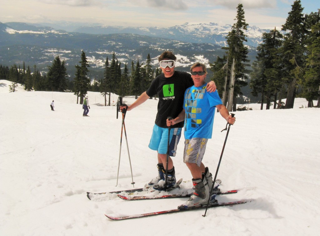
Mount Washington on Vancouver Island opened up one of their ski runs on Father's Day so Jordan, his son Aaron and gal Dee, and I drove up for the day. The 3 of them enjoyed the novelty of skiing in such warm weather with Aaron and Jordan wearing shorts and T-shirts! Me - not a skier.

Summer skiing

Nothing like a picnic by the ocean to escape from the heat (29°C/84°F!) So one day, Jordan and I packed up a lunch with champagne and headed out for a relaxing day watching the boats go by...and wishing we were on one of them!

Jordan has somehow been able to find a bit of time to get back into painting, which I personally think he is great at. His usual medium is watercolours, but his 1st attempt with acrylics for a wedding present made him want to try another, both of which turned out fab. I had copies of his paintings made into notebook covers with lined paper by www.MySkoobi.com. Cool!

A friend wanted to trade vehicles as he needed a truck for the weekend - so we got his powerful little red Mercedes Benz in exchange...a good trade I think! Speaking of cars, we went to see Tennessee William's play called A Streetcar Named Desire where the acting was superb.

We hiked at Englishman's River while staying with our friends at their cabin - what a great place to get away from it all!

Down by the river

Attended Taste: Victoria's Festival of Food & Wine, an evening of sampling scrumptious wines and tasty eats. Our favourites:
  • an oven-fresh delectable quiche made by Antichi Sapori Italian Food Company of Victoria BC (www.antichisapori.ca)
  • an aromatic red wine called 207 Freud's Ego with chocolate fragrance and oak taste brewed by Therapy Vineyards of Naramata BC (www.therapyvineyards.com)
  • a scrumptious, velvety cheese called Romelia by Salt Spring Island Cheese Company which was heated before spreading on a cracker to melt in your mouth (www.saltspringcheese.com)
One weekend, we hopped on the motorcycle and headed to China Creek Campsite at Port Alberni for a weekend of camping in a tent. Sleeping in a tent is something that neither of us has done in years. With temperatures around 25°C (77°F), it was a great riding and camping experience. We ended it by taking a scenic zig zaggy ride up and down Mount Arrowsmith on the way back to Victoria.

High altitude Mount Arrowsmith lake

And on the way back, we stopped at Parksville to take in the amazing annual sand sculpture contest.

A detailed sand castle about 2.5 m (8 feet) tall

And of course, went to the annual Symphony Splash where we were fortunate enough to watch from the best location, up close in a boat. (The Symphony Splash is where the Victoria Symphony performs on a barge located in the Inner Harbour to a crowd of thousands.)

We also enjoyed getting together with many of our friends and relatives. I headed off to several areas of the Prairies to visit my family (and celebrated my Dad's 80th Birthday!) and to see my very beautiful great granddaughter for the very first time...very sad to leave. While I was away, Jordan spent time in the Penticton area for a family reunion and his parents' 65th Anniversary!

After a productive stay at home, we are driving tomorrow to head south once again with a few detours along the way. After hooking up our new toy, The Wirie, on Sea Turtle, we should have great internet service access from our boat to hopefully post our adventures more frequently than in the past.