Friday, March 31, 2017

Tour time: Luxor

We and the crew from SV Jubilee were excited to get going for this day's tour around Luxor of Egypt. As our driver whisked us along, our guide Archaeologist Khaled, told us we were first headed to the Valley of the Kings to visit 4 of the many tombs there.

It has become prohibited to take photos in the Valley as over the years the ancient colours in the tombs have shown signs of fading because of it. They take a hard line on this, so our memory photos were purchased on site.

There has been a lot written about this site and its significant tombs, so we have kept it rather short. Needless to say, the endeavours of the ancients to prepare for the afterlife were amazing. To what extent you want to find more on this period, or the specific sites, it's all available by internet searching now.

King Ramses IV: The tomb of King Ramses IV has maintained to date a lot of colour on the wall paintings. He came to power late in life and ruled for no more than 6 years.


King Ramses IX: One piece of artwork on the walls on his tomb included a scarab. A scarab is a bug (actually just a dung beetle!) that was a symbol of eternal life and good luck.


King Merneptah: This is the sarcophagus (a coffin usually made from stone) of the King.


Tutankhamun (King Tut): Came to power at the young age of 9 and died approximately 10 years later from unknown causes. Over 5,000 items were found in this tomb including his golden sarcophagus and death mask.


When we visited King Tut's tomb, his mummified body was present for viewing. Eww! What we saw was his visible head and feet with the rest of this body wrapped in white linen and placed in a climate-controlled glass box for preservation and observation.


After the Valley of the Kings, it was over to Hatshepsut Temple where photos were now allowed. Hatshepsut married at the young age of 12, common in those days. The Queen's temple consists of 3 levels and took 15 years to complete; it is considered one of the greatest Egyptian architectural achievements.

Hatshepsut Temple

It's interesting to note that in those days, the people only recognized men as rulers, so Queen Hatshepsut was made up to look like a man. That was enough for the people to accept her as such and permitted a royal afterlife preparation.

To top off our tours, we went to the east side of the Nile to see the Karnak Temple. After Angkor Wat of Cambodia, this is the second largest religious ancient site in the world, and after the Giza Pyramids of Cairo, the second most visited historical site of Egypt.

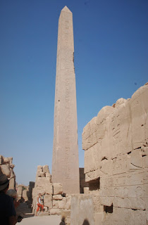
It consists of 134 massive pillars arranged in towering columns, several colossal statues, and an obelisk carved of solid granite 29.5 m (97 ft) tall and weighing over 320 tons.

Jordan and Judy by pillars

Judy beside a tall obelisk

How did the ancient Egyptians ever manage to construct such diametrically large and weighty projects! What makes Karnak different from other temples is the amount of time over which it was built - more than 2,100 years under several ruling pharaohs!

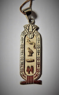
During our tours, our guide explained that a cartouche is a name spelled with Egyptian hieroglyphs enclosed in an oval with a horizontal line at one end which indicates the name is royal.

Cartouche in tomb at Karnak Temple)

If we wished, he said he could arrange for our names to be done in this way as jewellery. Here is my royal name (silver with gold hieroglyphics), complete with a raised scarab on the back!


Feeling all templed out, it was good to hit the road home to the comfort of Sea Turtle and to see how Chanty, our boat cat, made out without us for 2 days.

Thursday, March 30, 2017

Tour time: Aswan

The barren desert shores of the Red Sea are a long ways from the fertile valley of the Nile where ancient Egyptian life started and ended...and that's where we were headed.

04:30 in the cool predawn, we along with 3 from SV Jubilee, loaded into the tour bus for the journey to the Nile to see the great ruin sites at Aswan and Luxor.

The first 4 hours travel was over poorly paved roads that saw only military check points and a rugged inhospitable landscape. The looming Nile was announced abruptly by a refreshing greenery of agriculture that only belayed an increasingly dense populous of penury.

As we turned southwards along the Nile's east bank towards Aswan, our progress was hindered by the congestion of buses, cars, donkeys and carts, and overloaded sugar cane trailers pulled by tractors to the mills. About 400 km and 7 hours later, we arrived at the city of Aswan.

We snatched up Aswani, our Egyptologist guide, then stopped for an authentic Nubian lunch overlooking the river. The tranquil setting was complete with the motorless feluccas (traditional wooden sailboats with lateen-type sails) effortlessly gliding by in the light Nile breeze.

A felucca sailing the Nile

Our first stop of sites of antiquities was the granite quarries used by the builders of the ancient wonders of the Nile to see the Unfinished Obelisk. They were a noted feature of that era's architecture and were required to be made from one solid granite stone. Pairs were placed at temple or tomb entrances for sun gods or others displayed as tributes to kings or queens.

But the Unfinished Obelisk was just that, never finished. It was the largest attempted. During the labourious carving of it out of solid granite, it was discovered it wasn't so solid. Crack! As a crack would be considered an insult to whom it was made in honour of, so progress was halted. And there it sits, in an unglamorous repose.

High hopes cracked

From there, we drove to 2 dams built on the mighty Nile River, the Aswan Low Dam (aka Old Dam) and the Aswan High Dam. The Low Dam provided irrigation but could not prevent the floods. So in the 1950s, the High Dam was built 6 km upstream that could provide valuable irrigation, end the annual flooding of the Nile, and bring electric power to Egypt to light homes and power industry.

Then it was off to the Philae Temple. This Temple was originally located on the Island of Philae but it was constantly being flooded after construction of the Aswan Low Dam. So to preserve it, they had to move it piece by piece about 500 m away to Agilkai Island to be reassembled where today it can be accessed by boat. An impressive feat!

Massive relocation project

Long corridor with just us

Finishing then in Aswan, we headed to Luxor where our hotel was waiting for us. Backtracking for the first couple of hours, then a couple more continuing along the rough road north along the Nile, we arrived late, tired, and hungry.

After a hasty check in, we headed to the busy rooftop restaurant for a typical Egyptian dinner as a 4-piece traditional band sang and played LOUD music. It would have been impossible to sleep so we stayed to watch a couple of following acts accompany the music.

The next act was an urban Whirling Dervish. He was like the Rhinestone Cowboy of Dervishes. His costume was a layered psychedelic affair of light and quilted colours that, with a glass of wine, also got your head spinning like a dervish. As he non-stop twirled, a few different layers would be discarded, giving a new appearance. Very good and entertaining. And he didn't fall down when he stopped twirling.

The following act started with the opposite amount of attire - an Egyptian belly dancer. That ended our first long and full day on tour.

Tuesday, March 28, 2017

A day of diving

Being Med-moored right next to 2 dive boats and continually watching them load up and take off for the day was enough of an excuse for Jordan to book on. After all, the Red Sea is considered by some as giving the best diving experiences in the world. Joining him were 2 crew from Jubilee.

Jordan said it was generally a pretty good dive in an abundance of healthy coral but the water left them chilled even though they wore wet suits.

Here are some nice shots he got...

Multitude of colourful corals

Blue-spotted stingray

Masses of fish and coral

Friday, March 24, 2017

EGYPT

The Red Sea is 1,400 miles long - that's 1,216 nautical miles - and we average 5 nautical miles per hour (5.75 mph). That's over 240 hours for Sea Turtle to get through the Red Sea without stopping!

And the Red Sea has 365 days of sunshine per year (yes, 365) and it is surrounded by desert. The winds blow predominantly from the north and when it blows hard a fine desert sand covers the boat painting it a red hue.

Progress north can be a test of patience. Headway is done either by motoring in calm weather or, more often, beating into light north winds. In the latter case, a typical day starts at the crack of dawn or before and then, usually by noon, when the winds have picked up to the point of pounding into it, we look for shelter.

So this day, March 22nd, with a forecast of 2 days of calm, we made a run for it. It was a predawn start in a velvet darkness. The anchor was hoisted under torchlight and we motored out of the inlet of Marsa Wasi (Sudan) guided only by our GPS track laid down on our electronic charts when we entered.

We would be growing moss if we waited for a following south wind to sail north with. So we welcomed the calm even though it meant motoring and using precious diesel fuel.

Sea Turtle has large fuel tanks and the new Beta motor sips it slowly. This has been beneficial as available fuel stops are few and far between on this passage. And having a watermaker takes away the worry of finding fresh water.

Just after midnight at about 22 degrees north and in flat seas, we crossed into Egyptian waters. It was now March 23rd and as the day progressed, we lost the calm and a north wind developed making our last 10 NM to our destination a tedious affair as we motor-sailed into a steep chop.

We tied up to the Customs/Immigration seawall of Port Ghalib Marina (N25°32.021' E034°38.338') on March 24th at 09:30 (08:30 local time) right behind SV Jubilee who had arrived about 7 hours earlier. We received a friendly welcome by the officials and as soon as the paperwork and thorough inspections were complete, we Med-moored right in front of a hotel and swimming pool.

Sea Turtle at Port Ghalib

Twenty years ago where Port Ghalib is now, was a barren, rocky, windswept, and uninhabited desert coastline. Then a Kuwaiti billionaire invested a reported 2 billion dollars to turn this port and 18 km of coastline into tourist resort destinations complete with a town center, shopping, hotels, restaurants, marina, etc.

The Marina has a unique set-up with different waterways connected by small walking bridges for pedestrians.

Tuesday, March 21, 2017

Two marsas in two days

The morning had started out with calm winds as we departed Khor Shinab (Sudan). But it didn't last for long. This day, as is typical for  this part of the Red Sea, as the day builds so does the wind from the north. So only making a mere 10 nautical miles in 3.5 hours pounding into short steep waves we turned in through another break in the reef and down a channel

The blustery winds followed us down the flatter protected waters of Marsa Abu Imama's channel whipping up little white caps. We dropped the hook early in the morning at 09:30 on the 20th (N21°29.497' E036°57.212'). A short day's run.

Remarks in the Red Sea cruising guide called this a peaceful and beautiful spot. Unfortunately we were unable to see most of it due to the haze created by the blowing dust. But it was peaceful being the only sailboat there, or for that matter, anywhere.

Since we left SE Asia on this passage, we shared anchorages along the way with the same 3 boats. But by now we have all separated, progressing at different paces. Other than those, we haven't seen another sailboat. We have only heard of about 3 other boats that have or are making this short-window passage to the Med.

But there were a couple of lonely and lowly fishing pangas who approached us asking for whatever they could think of using only a few words of English. We had nothing but a shirt and some aspirins for their needs as our supplies had been getting very meagre by this point.

A calm dawn of clear air showed us the 3 conical sets of hills and an appreciation the beauty of the desert beauty.

Small sample of mountainous Sudan

Still packing remnants of dust storms

The winds were predicted to be from offshore and fairly light so we headed out early. But again we had to pack it in for the day after only 3 hours of bashing into headwinds making barely 10 nautical miles to the good. We found protection at Marsa Wasi down a short channel and anchored next to a long sandspit on the 21st (N21°38.551' E036°54.001').

Stretched out sandspit

Red sky in the Red Sea

Monday, March 20, 2017

Khor Shinab's hold

Our early morning departure from Taila of Sudan on March 18th saw us safely away from the coral bommies which were easily seen in the clear water. As predicted, the north headwinds had abated so we were motoring to continue northwards up the Red Sea. It was about a 50-nautical-mile run to our next destination, Khor Shinab.

Fishing has been awesome in the Red Sea. Experience has it that shortly after putting out a line, fish is caught. Jordan caught another, this one a bit smaller, but for only two of us, that's preferable.

On our way, we passed Leoni reef anchorage, reputed to be the best snorkelling; we just had to stop and see (N20°54.920' E037°15.640'). Our consensus? The best in the Red Sea yet.

Coral garden

Varieties of coral

Along the way, a small panga with a couple of friendly fishermen approached, asking if we had any soft drinks. Unfortunately we only had one Cola which they gladly accepted. And it was cold too! We also accommodated and gave them an older snorkelling mask to their delight. Heading off, as their boat bounced on top of the waves, the mask was being tried on top of bright grins.

As the day progressed, the winds steadily built. This time it was in our favour and we were running down to our next anchorage, so by the time we made it there in the late afternoon, it was at least a lively Force 6 on the Beaufort scale.

The only suitable anchorage was at the end of a 2.5-nautical-mile long channel that led inland. Even after anchoring (N21°21.090' E037°00.881'), we could tell the wind's escalation hadn't finished. It was here that we experienced the notorious Red Sea's namesake. The skies darkened and the desert scene was obliterated with a howling atmosphere of sandy dust. Poor Sea Turtle was covered with the fine dust that forms the top layer of this African desert. All the saltiness of the boat was like a magnet for the stuff and Sea Turtle took on a dirty rouge tinge. There was even settlement inside.

It's dust, not fog

It's dust, not a lightsaber of Star Wars

The next morning, the wind was light and variable so Sea Turtle's anchor came up and she swam the mile out to see what it was like out in the big blue. By the time she got to the outside entrance, the winds had really picked up and from the north, the direction she wanted to head. So when she stuck her nose out, seeing the boisterous sea state, she turned tail and swam all the way back up the channel returning to the safe hangout to wait for another day (N21°21.061' E037°00.832').

So when we awoke early March 20th, the wind was quiet. We quickly brought up the anchor and hurried out to sea. Khor Shinab had given up her hold on us!

Friday, March 17, 2017

Taila Islands

We awoke to a certain calm on March 15th. Even though the forecast was for more strong winds, we thought we would say goodbye to our buddy boat and try a quick 12-nautical-mile jaunt north where according to the Red Sea cruising guidebook was a suitable anchorage that protects against a north wind.

As soon as we rounded the point with only a light breeze, there were steep, short, residual waves that required us to fall off enough to avoid bashing into them. After an hour, we finally got on the lee of a large offshore reef that calmed the sea enough for a direct approach to our day's destination, 3 small sandy cays on the extended coral platform of Taila (Sudan).

As usual, it was approaching in clear water, and with the sun at our backs, we safely anchored in a patchwork of coral and sand. The lee side of the Taila islets provided a good protection from waves but not from the whistling wind that passed right over the low laying atolls. We could deal with that. We settled into a slow pace of activities here for the next 3 days to wait out the north winds.

After strolling the beach, we did some snorkelling on the way back to the boat. What was becoming evident was the drop in temperature of the air and the water as we increased our degrees of latitude but not enough to stop us from snorkelling which we do whenever we get the chance. The Red Sea's healthy coral and sea life and water clarity make it a first class dive destination in that respect.

Colourful soft and hard coral

There is always something for the sailor to do to fill their time. Upon discovering our wind indicator on the deck of the boat, Jordan climbed the mast to reattach it. Was it a bird or the wind that knocked it down? While he was up there, the rigging and all things get an inspection. This time it required new zip straps to secure the spreader light wires.

The Tailas from above

Chanty's kept busy too!

During our stay here, several small fishing pangas were spotted at the next tiny cay. They too were waiting it out on the protected side. One of them came over to Sea Turtle and asked if we wanted any fish. As we still had plenty of our own, we declined.

Their intention had probably been to trade fish; they asked if we had a few items such as cigarettes, sugar, or coffee. A non-smokers and only having a small amount of coffee left, we couldn't help them there, but we had lots of sugar so gave them a Ziploc bagful. Jordan treated them with 4 beer. They left very happy!

In high spirits

Tuesday, March 14, 2017

What? Evicted again?

March 13: Just before daybreak, we crept out of the sleeping Port of Sudan. Again, beating into a breeze, we were heading north for Marsa Arakiya. The guidebook had shown it was an anchorage with a friendly military presence, but after 8 hours of motor-sailing, we discovered that this was not to be.

As soon as we were about to anchor (N20°13.872 E037°12.249), we were once again immediately ordered to leave.

Okay, now where? The concern was that the next available protected anchorage was further north and the winds were picking up by this time. To make it before dark, we had to motor-sail into a good opposing chip, tacking back and forth to avoid bashing directly into the waves. With just enough light to make our way through some coral bommies, we anchored in the lee of Wreck Point by Marsa Salak (N20°27.729 E037°13.835).

Wreck Point anchorage

This became our haven against 2 days of strong north winds.

Sunday, March 12, 2017

Evicted

After an enjoyable stay at Suakin, we pulled anchor at 06:45 and continued our coastal journey north cautiously beating into a light breeze through reefed channels.

Old Town of Suakin

Later that afternoon just north of Port of Sudan, there was an unnamed channel in through the reef which we chose for a night of protected anchorage (N19°39.507 E037°14.580). But just after we anchored, a military launch approached with horn blaring and demanded with no Ifs Ands or Buts that we leave as this was a restricted military area.

They ushered us back down the coast a few miles and had us enter the Port of Sudan, a stop that we tried to avoid as it normally requires the expense and hassle of checking in. We simply wanted a safe place to anchor and be off the next day.

By the time we anchored in the tight confines of the harbour in front of the town and beside the commercial pier, it was nigh 18:30 (N19°36.490 E037°13.388). It was a long day with some frustrations but on the positive side, we avoided the complicated official check in by a super nice official and internet was excellent.

We had to crane our necks to look up

Saturday, March 11, 2017

Around Suakin

With some spare time, Jordan and I walked around the indigent town of Suakin (Sudan) which in spite of its condition presented us with many cheerful smiles plus some photo ops.

Portrait of contrasts

Best friends forever

Building in town

Clothing for women was very bright and colourful in most instances. Typical wear for men was usually a white caftan over their regular clothes with either a cap or turban.

Lots of colour on a windy day

Transportation of people and/or items was by donkey, bicycle, walking, or the very seldom seen car.

Beast of burden

To market, to market...

Suakin

The day's destination was the town of Suakin in Sudan to do our official check in. It was about 6 hours away from Harorayeet (Two Islets). We left at 06:30 motor-sailing with barely a whisper of wind. But the tedium was soon broken by the shuddering fishing rod eliciting an exciting Fish! Fish! as cat and master ran to reel it in. It was a nice mackerel, its excellent light meat enough for a few meals.

Reel good

We entered a break in the reef for a mile long transit down a channel that ended at the town of Suakin. We passed an area of the old town on Suakin Island that was in ruins and looked like the remnants of bombs. But not so. Many decades ago, that part of the town was abandoned as the main port for the area and people and commerce flowed north to another town, Port of Sudan. So the buildings had simply eroded away and crumbled down with no maintenance.

Harsh desert erosion

Walking the ruins (after we anchored)

Once again at anchor (N19°06.510 E037°20.278), we had our paperwork tended to by a required Agent, Mohammed. He was dressed in the typical attire for this area: a long, white, flowing caftan replete with white rounded skullcap (called a taqiyah) that presented a stark contrast to his dark skin and dusty environment.

Agent Mohammed

Other than checking us in officially, his services also included fuel delivery by 50-L jerry jugs, taking our laundry to town, providing a SIM card for internet, arranging a tour for the next day, and providing a shore pass for us. His Agent fee was a reasonable $40 US.

Mohammed took us on a tour, along with SV Jubilee, to the Abu Hadab Museum of Folklore. Along the way to the Museum which was on the outskirts of town, we had a camel faceoff.

Calf only a few days old

The Museum was a collection of early photos of Suakin Island and the ruins as they crumbled to their demise. Also on display were bits and pieces of brass containers, urns, furniture, and clothing. History has it that Suakin was a significant port of seafarers for hundreds of years including the slave trade. Slave trade in the Middle East was happening centuries before it arrived in the Americas.

3 from Jubilee with us and an employee (courtesy of SV Jubilee)

The town's stores and markets were able to supply us with only basic groceries and produce.

Colourful selection of the basics

Typical street scene

Thursday, March 09, 2017

Harorayeet (Two Islets)

After a good night's sleep, we headed out on what would be a short day sail over to Harorayeet, also known as Two Islets. We first thought our anchorage would be at Dhanab Al Qirsh (aka Green Reef), just past Harorayeet, but as we approached we could see that the labyrinth of reefs made it a perilous choice. So we backtracked to the two small islets.

It was a good choice. We anchored safely (N18°53.334 E037°45.717) between the two lovely islets in 9 m (30 ft) of sand out of the wind and waves.

Our first sight was an indigenous fisherman motor-sailing his small panga past. He had obviously made the sail and it seemed to be doing an excellent job.

Home-made sail

We dinghied ashore with Chanty. This was still new to her as she is strictly a boat cat. She scrambled along the hot sandy beach not really enjoying it so we took her back to Sea Turtle so that we could beachcomb at our leisure and found it to be yet another great spot for shelling.

Can I go back now?

A ways off the shore, we saw two large eagles that were paying too much attention to us. We found out why soon enough when walking through the low bush we came across a nest of sticks, just lying out in plain sight, and sitting perfectly still were two well grown eaglets staring straight ahead. As exposed as they were, the makings blended in perfectly with the weathered twigs of the next. We silently crept away so as not to disturb them as frantic parents flew overhead.

We also walked past several dead turtle shells and/or skulls which were distressing to see. Here, turtles are eaten and not considered an endangered species, though they probably are.

Easy prey for fishermen

We snorkelled back to Sea Turtle as we dragged the dinghy along behind us. There was a lot of coloured coral and several bright fish.

Brain coral and colourful clams

We had company that night in the anchorage. A couple of fishing boats called this their night's stop as well so we stopped to say hello. They spoke no English but were very friendly and showed us all their fish. We returned to Sea Turtle and contemplated our good fortune of a comfortable boat compared to their evening in an open boat with lots of smelly fish in a Styrofoam ice chest, an open fire in the bottom of their boat to cook their late meal, and a couple of wooden slats to sleep on.

Opposite of luxury