On the way down, we stopped at Reno Nevada (N39°39.385' W119°53.125') to watch the annual air races on Sunday. A lot of beautiful planes, first-rate races, and some great air displays too.
A "Rare Bear" plane
The Canadian Snowbirds put on an outstanding performance to the delight of the audience...
Unfortunately, there were 2 incidents: a plane crashed during the second last race where the pilot walked away with cuts and bruises but destroyed his plane, and the much awaited final race did not come to fruition as officials deemed that the wind was too strong to have a safe race. The guys were real disappointed, but safety first.
That night we stayed at a small town called Tonopah (N38°04.175' W117°14.019') about 3 hours before Las Vegas in the Clown Motel. Very weird - there were literally clowns everywhere - on each motel door, pictures in the rooms, a lobby totally filled with clowns - but the parking lot was highly lit so we felt Aaron's motorcycle in the back of the truck would be secure (ours is in Palm Springs Arizona). Tonopah has an interesting, very old, entirely wooden cemetery:
1901 - 1911
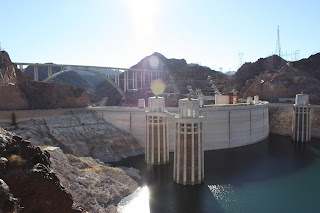
Just before Vegas, we made a small detour up to the state park on Mt. Charleston (N36°15.271' W115°38.450') where surprisingly there is a pine forest, vacation homes, and even a ski hill. After a quick drive down the Strip (Dee's first time), we headed east over Hoover Dam (N36°00.490' W114°44.350') where we saw the spectacular new arching bypass bridge that spans over the Dam and the Colorado River. Check out the amazing construction details on Google.
New bridge over the old
From there, we made it to Williams Arizona (N35°15.090' W112°11.030') on the historic Route 66, a cute little town with a western mining theme neighbourhood, the Wild West Junction, as this gentleman indicates...


No comments:
Post a Comment