Cool Stuff

Friday, December 23, 2011

On to mainland Chile

Easter Island is a vulnerable place for sailors, so we needed to get going. Our next passage would be to the mainland of Chile (Easter Island also belongs to Chile). So we walked to town, stopping at the Armada office to notify them of our intended departure - a requirement - and to check their weather forecast which looked favourable. We then went to market for provisioning. We needed mostly fruits and veggies and found everything we wanted. The produce was very good quality (best arugula ever) but not cheap like Ecuador.

At about 15:00, a few officials came down to the boat where certain departure procedures were done.

Once everything was ship-shape, we untied our lines from shore and the concrete jetty as we officially headed out at 16:00 on December 13th (not a Friday!) For exiting the harbout, we were granted permission to use our own waypoints instead of hiring a pilot (I had written down waypoints when we followed the barge in on December 7th). Under sunny skies and warm temperatures, we motored out of the tiny Harbour Piko, with wind on the nose, until we could bear off and rounded the SW end of Easter Island with just a poled head sail.

So long, Easter Island!

We had expected to be running under good wind conditions as long as we could stay away from the high pressure zone on the southern fringe. The strategy was to head south of the rhumb line before turning towards our destination. But the high seemed to overtake us, pushing us further south. We went from good wind the first day to being totally becalmed - we even put out our flopper stoppers to stop the constant rolling as we waited for wind, not wanting to motor so soon on our long passage (expecting about a 21-day voyage). Several days, we only made a direct southing track as we tried to pick up some more winds. A couple of those days were under power to try to escape the calms.

Jordan saw his first great wandering albatross on December 19th. Unfortunately I was sleeping and missed it but we saw more later throughout our passage. They are big birds and look like they fly in slow motion, wingtips flitting along the wave crests, gliding on a cushion of wave wind, barely ever a flap.

Finally on our 7th day out, we had a great day of sailing with a light to medium downwind, running a direct line east to Puerto Montt.

One chilly day, Jordan decided to put on his moccasins as his feet were feeling cold. We both laughed as he hilariously slid from port to starboard continually, unable to stay in one spot with Sea Turtle's heeling. I also dropped 10 eggs, breaking them all. Fun and angst on the high seas.

December 21st is the shortest day of the year up north, but the longest day of the year where we are. It was also a good day sailing with lots of wind, but mostly overcast and some rain. Next day, had one anxious moment when trying to furl the head sail in. The furling drum spun but the sail did not furl in. Thankfully it was only a loose set screw which Jordan quickly tightened.

Easy fix in daylight...

But then a few hours later, we were treated to an outstanding sunset...


Jordan describes the gliding birds:
I love watching these birds about the size of seagulls. They are fast yet hardly ever beat their wings. They streak along the front crest of the swells or waves with wingtips maybe an inch from the water, the peel up about 30 or 40 feet in a fast tight turn and at times almost upside down to make another run at it. They look like fighter pilots making low level bombing runs then peeling up for another strafing.

Tuesday, December 13, 2011

Dirty deeds done cheap

Our plan was to go to the veggie market today as we knew it would be open but Jordan had a dirty job to do and wanted to finish it before going to town. Cleaning the oily bilge...yuck...it ended up being an all day job. Also 1 of the 2 bilge pumps had previously quit working and when he couldn't fix it, he removed it from the slime - another thing to add to the "to buy" list. Oh well, hopefully the market sellers will be around again tomorrow.

Now that our sightseeing had come to an end, we reflected on the intrigue of what we saw. The curious and fascinating past of the original inhabitants and their bizarre endeavours and the remoteness of this island will make Easter Island the most unusual and thought provoking place we have visited.

Monday, December 12, 2011

Wrap-up tour

Ana Kai Tangata - Today at Easter Island we went cave exploring at a cave whose name means "Cave Assemble Man", or in other words, a place where man gathers. Paintings of the Sooty Tern bird are on the cave ceiling, but now, with humidity and the presence of man, only fragments remain making them impossible for us to distinguish. The Sooty Tern is the bird whose egg was sought in the Birdman Competition at Orongo.

But it is a great view of the coastline from inside the cave or from above it. With a tide variance of only 1 m on Easter Island, you are always safe inside the cave.

View from inside Ana Kai Tangata on a calm day

Museum - The museum is small but has some interesting artifacts of note. One being fragments of an original moai eye that was discovered beneath an ahu (platform) at Anakena beach in 1978 shown below...

Red scoria & white coral eye

As very few eye fragments have been discovered, it is thought that they were only used for particular ceremonies on some moai.

There are only 2 replica Rongo Rongo tablets on display as the 27 original are all in other museums overseas. The script on these wooden tablets is still a mystery today. Are they some mysterious language? Are they symbols used as an aid in story telling?

Basalt fish hooks, dental and sewing implements, sketches of boat-shaped houses, obsidian spearheads and other weapons...just a few of the many items to view. Only a small percentage of the 15,000 artifacts in the museum's collection are displayed.

13:30 and it was time to return the motor scooter after 3 days of harried exploring.

Moto and moai

Back at our mooring, we once again watched the 2 resident sea turtles swimming about. They don't seem to be afraid of humans and hang out interested as the fishermen clean their catch, but of course they don't eat fish. We also found 1 that was lazily soaking up the sun in the shallows. The turtles we saw all had shells about 1 m long.

Two torpid turtles

The local fisherman gave us 2 more delicious fish today for 1 beer and 1 cola - sounds like a good deal to me! Then this afternoon, Jordan cleaned the bottom hull of Sea Turtle. It had a few gooseneck barnacles but otherwise was in good shape. And the ocean water was also fairly warm.

Another sailboat, Odyle, arrived today but as it was too big to be in Harbour Piko, it anchored out where we had been the first night.

Sunday, December 11, 2011

Our highlight

This morning, Jordan locked the dinghy to the stern of Sea Turtle with just enough lead so that we could grab onto the mooring ropes and slowly pull ourselves to the concrete wall where I would pull myself up onto the top of the wall. Jordan would then move the dinghy over to the slippery concrete jetties and tie a retrieval line there as he scrambled ashore. It was now out of the reach of children!

Rano Raraku - Today we headed for the quarry, about 18 km from Hanga Roa on Easter Island, where the moai (statues) were extracted from the rock cliffs which are the back side of an extinct volcano. There are almost 400 moai left here in various stages of completion. As we approached, we could see the side of the volcano studded with moai, gazing outward.

Volcano Rano Raraku with 100s of moai

Many for the most part have been partially buried over the years from falling earth, carving residue, and general erosion. So what is visible are mainly the heads of the moai (which are only about one third of the size of the entire moai) with the bodies now covered. These moai have never been restored or re-erected - they are in the same positions as when work at the quarry suddenly and mysteriously ceased.

Many moai through the years are now partially buried

So basically, here's a theory of how it works. The moai was carved lying on its back with all details completed except eye sockets. The moai's back would then be chipped away at the spine from the tuff (hardened volcanic ash) and carefully slid down the volcano slope with ropes and pulleys and no doubt everyone hoped for no accidents!

Can you spot this 21-m moai still on its back?

It was lowered into a prepared pit or trench where the back of the moai may have had designs carved on it and then somehow transported to an ahu (platforms throughout the island) where it was erected, and the eye detail completely carved.

The largest moai ever carved (above), though not freed from the bedrock, was just under 21 m in length, 4 m across the shoulders, 1.5 m thick, and a weight greater than 200 tons! Even then, the bigger the better. (Largest moai ever placed on an ahu was 10 m high.)

There are numerous theories as to how the moai were transported and erected. An amazing feat considering the size and weight. If a moai broke, it was abandoned, even though it probably took a year or more to carve. Sorry, boss! The popular theory is that they were transported standing up, rolled on palm logs. It is believed that the island was originally covered in palms, but they were wiped out by the obsessive moai construction and transportation. Palm trees now present have been imported from Tahiti.

Half buried moai

We walked the many trails heading up and around the volcano, seeing so many fascinating moai.

What are they looking at?

A most unique moai was excavated in 1955 because of its unusual head shape and appearance (rounded head sporting a goatee). It was then discovered that it was kneeling, making it one of a kind.

Tukuturi - almost 4 m high

We also walked to the inside of the volcano where there was a lake and a few outriggers practicing for popular competitions. There were about 80 more moai to be seen around the lake, but we were not allowed to get close to these without a guide.

Very pretty scene in crater

Saturday, December 10, 2011

To the beaches & more

Today we wanted to check out the only 2 beaches on all of Easter Island and give snorkelling a try. So we headed up to the north end of the island, about 30 km away.

Tahai - But our first stop of the day was a site called Tahai, only 1.5 km from Sea Turtle. This site was restored in 1968, meaning that the moai (statues) were raised to a standing position on their ahu (platform) which were also repaired. And 1 even had a replica set of white coral eyes added. The eyes show how alive the moai then appear.

Ahu Vai Uri - 5 moai were re-erected but 1 reposed that was too badly damaged to be restored and placed with others on Ahu Vai Uri was left in its found position.

Judy with the resolute ancients

Lone stone head - This crudely carved head was discovered in the rubble of the Ahu Vai Uri (above) and is perhaps the earliest human representation to be carved on Easter Island.


Ahu Ko Te Riko - It was decided to place a replica set of eyes in this 1 moai during restoration. As so few fragments of the original white coral & red scoria eyes have ever been found, it is believed that only a few were ever made and then used for ceremonial purposes. (Red scoria was the material also used for making the topknots.)

Look, I'm down here!

Also at this Tahira site, can be seen 1 of several canoe ramps on Easter Island made by the original people. There are only 2 sandy beaches on the entire island, making it a very difficult for them to land on the rocky shores.

Some islanders elongated their ears and some did not. Each clan made their moai as they were, with either long or short ears. But most moai never changed much over the years except in size and detail. Almost all moai face inland, overlooking and protecting the village, but there are a couple on the island that face out to sea. It is believed that when a village was near the sea, the moai that face out to sea were in fact overlooking a former village located there.

Anakena - Next stop was the beach at Anakena. Around 700 A.D., the first Polynesians landed on Anakena beach, as most of the rest of this island is rocky shored. We walked the beautiful white sand beach and then plunged into the warm ocean and snorkelled but saw very little ocean life in the clear waters. Disappointing. The ocean temperature ranges from 24° C in summer and 18° C in winter.

Palm trees, white sand, and moai

Ahu Nau Nau - There are 3 ahu at Anakena but the star is Ahu Nau Nau with 7 moai that display exquisite detail which had been preserved by being buried in the sand before being restored in 1978. Fragments of an original moai eye were discovered beneath this platform and is now on display in the Hanga Roa Museum.

More detail displayed in gallery photos

Ahu Ature Huki - This is the site where the first moai on the entire island was re-erected, by the legendary Thor Heyerdahl in 1956. There is a small brass plaque on the ahu commemorating the event but fencing restricts viewing of it.

Fence won`t allow us to get any closer (the beach is right behind this moai)

Ovahe - This is the second of the only 2 beaches on Easter Island and it is only about 1 km from Anakena beach. No tour buses go here and very few people so we wanted to check it out. It was a little difficult to find, but after many wrong turns, there it was! As predicted, there were only a couple of sunbathers in the small cove with glistening pink sand, and another couple of swimmers in the turquoise waters...heavenly...

Tiny cove of Ovahe beach with pink coloured sand

Te Pito Kura - We next stopped to see the largest moai that was ever successfully moved and erected (but not the largest ever carved). It is 10 m tall and weighs 80 tons and was also the last moai to be reposed, sometime after 1838.

Ahu Tongariki - 15 colossal moai, with the heaviest weighing 88 metric tons, on an ahu of 220 m long - the biggest ahu ever built. Wow! All of these moai were toppled during the warring period of 1770 to 1838 but were then restored from 1990 to 1996 after more damage of a 1960 mainland Chilean 9.3 earthquake and tsunami with waves of 11 m.

Of the 15 moai, only 1 with topknot

Travelling Moai - Japan financed the restoration of Ahu Tongariki in the 1990s with the contribution of a huge crane and $2 million. As mentioned above, moai had been previously toppled in the warring period but were then further damaged and tossed great distance in the 1960 tsunami. This moai visited Osaka and Tokyo in 1990.

The Travelling Moai, with Ahu Tongariki in background

After another exhausting and exhilarating day, when we returned to Sea Turtle we noticed by little muddy footprints that once again kids had been out in our dinghy and decided that we could no longer tie up to the stairway to get ashore.

Friday, December 09, 2011

Orongo & birdman festival

We purchased an excellent up-to-date book entitled A Companion to Easter Island by James Grant Peterkin and found it extremely useful. At the same location, we rented a motor scooter for 3 days as we knew we had a lot to see and would be travelling distances too far to walk. Our first choice was the restored ruins of the ceremonial village of Orongo.

Orongo is perched precipitously on the rim of the large volcanic crater Rano Kau. The site has a 1,000 m vertical drop to the sea on one side and a steep slope into the crater on the other side. It was about 7 km south from Hanga Roa (the only town on the island) along a twisting, winding, dirt road with lots of potholes, but a very scenic drive on our motor scooter.

We looked down at the crater's lake surface covered with mats of freshwater reeds. The vista in the other direction brought the blue expanse of the Pacific up past 3 small islets called motus. Moto Nui, the largest, was the arena for the "Birdman Competition". The tribes of Easter Island had been warring amongst themselves (1770-1838), with moai (statues) being toppled all over the island. It is believed that the Birdman Competition was started after this destructive period, giving the winning tribe leadership for the year - which was gained through physical prowess rather than status and rank.

Moto Nui in the far background

The Orongo village was only inhabited during the month long Birdman celebration and tough competition for which competitors may have prepared for all year long. We took photos directly in front of the stone "row" houses that people involved with the ceremonies used, not knowing that it is a definite no-no to get off the path and up close. Pictures are allowed but no one is allowed to be this close as the park ranger informed us when he pointed out the signs. These houses were only used for sleeping or a respite from bad weather, and cooking, etc. was all done outdoors. Some of the houses had indoor passages between them.

1 of 54 village houses restored from 1974 to 1976

The Orongo site was used previously for religious ceremonies but construction of the village made it the most important center across the whole island for rituals. The stone village houses were oriented to face out to the 3 islets.

Upon a signal, the competitors would scale down the steep cliffs, swim 3 km on a pora (a reed surfboard) with a few supplies to 1 of the islets called Moto Nui (big islet) where they would camp in caves, anxiously waiting...

And the first to claim the newly laid egg of a Sooty Tern bird, that turned up annually to nest, would be the winner. But then he would also have to swim back, climb back up the cliff and return to Orongo, without breaking his claimed egg which he would carry in a pouch tied to his head. This was considered a very big honour for the competitor, even if he was performing for his Chief who would then be named as the official Birdman of the year. The last competition was held in 1866 when it was discouraged by Catholic missionaries as the event involved worshipping of false gods.

Unfortunately, the 1 statue that bridges both the moai and Birdman periods was removed from one of the stone houses in 1868 and is now located in the British Museum in London. It was made of basalt which was not the usual material for statues, has notable carvings on its back, and was probably used in the coronation of the Birdman. We never saw any moai at Orongo and only the remains of 1 ahu (statue platform).

Vinapu - After a very self-informative afternoon at Orongo (only 1 descriptive sign and no pamphlets), we left and headed to the SW corner of the island to the nearby site called Vinapu. Vinapu displays 2 of the stone platforms called ahu and several toppled moai with their faces in the dirt. But what is so unusual about the ahu at this site is the perfectly carved tight fitted stone blocks, up to 6 tons in weight, with no cracks or holes between them, reminiscent of the Incas in the Cuzco Valley of Peru.

Precision work on Vinapu 1 (also called Tahira)

Also here is a red statue made entirely from red scoria that is believed to be a female moai. Firstly, very few female moai have ever been found, and secondly, red scoria was used to carve the topknots and eye pupils - not the statues themselves. The topknots are the large crowning of the moai and sort of look like hats to me!

Typical topknot

We then returned to Sea Turtle whereupon a returning fisherman asked us if we wanted some fish. Of course we graciously accepted; he then scaled 2 fish and gave us his recipe. We figured if it comes from a seasoned fisherman, it must be good - it was delicious!
Fisherman Recipe
Have a pan of water (large enough to contain the fish) heating to a boil while you remove scales and discard innards of fish. Do not cut off head, tail, etc. Cut diagonal slices into each side of the fish. Sprinkle with a seasoning salt on both sides of the fish, into the slices you made, and into the gut cavity. Fry the fish for only a couple of minutes on each side. Then place the quickly fried fish into the boiling water. Boil for 5 minutes and then thoroughly enjoy the delectable, moist taste.
Scaled, cleaned, and sliced

We got into our dinghy and noticed how dirty it had become. While we were gone, kids had climbed in with their muddy little bare feet and paddled around the harbour. They had earlier asked when we first left the dinghy by the stairs and we said no as we were worried about the safety of both the dinghy and the kids. They took it out anyways unapologetically! We guessed it's the way here.

Later that evening, we came back to town to watch a 1993 movie that is shown 3 nights/week at the Hotel Manavai called Rapa Nui (Polynesian for Easter Island). While watching the movie, I tasted my first Pisco Sour, a very delicious and well known alcoholic beverage throughout Chile. The movie was filmed on Easter Island and produced by Kevin Costner. It has great scenes of Easter Island and the love story is about the Birdman Competition. If you can find a copy, rent it! The events depicted in the film are pretty much as it was, anthropologically speaking.

After a long and exhausting but fulfilling day, we fell asleep very quickly as we anticipated what tomorrow would bring.

Thursday, December 08, 2011

Getting ashore

My biggest fear of coming to Easter Island was not the passage but in the event that we had to anchor out, would the weather be co-operative enough so that we could both go ashore at the same time? At anchor, you are required to always leave someone on board. Apparently, the weather is unpredictable and winds can, in a short time change, necessitating a dash to the lea side of the island. But fortunately, we were able to make it into the tiny cramped harbour and no doubt because we had come in December which is Easter Island's summer season. The weather was hot and sunny with not too much wind.

After arriving on December 6th at 20:00, we spent our first night anchored in the company of a small freighter out in front of Easter Island's only town, Hanga Roa. Shortly after anchoring, we made contact with the Port Authority on Channel 16, as required. Their office was overlooking us. Arrangements were made to process our entry to this Chilean port for the next morning when we were duly boarded and processed by 6 friendly officers from various departments. They confiscated our honey and gave instructions such as "No garbage ashore" and "You must have a pilot to enter Harbour Piko" (the tiny harbour only 4 m deep just around the rocky point).

They also said that we could bring no fruits or veggies ashore and all such, including any that we purchased at Easter Island would have to be eaten before we arrived at mainland Chile (Puerto Montt) our next destination. We got some friendly chuckles when they asked if we had guns and Jordan's answer was "Oh, no. We are Canadians."

As they left, we asked them to send a pilot out and soon a fisherman in a panga showed up and said he needed to get police approval and would be back in 2 hours.

Our electronic charts showed range markers for the harbour entry but we had read that the local word was that when the range markers were installed by the Chilean government they didn't consult the locals and the path was dangerously close to a reef of hull-eating volcanic rocks. So after waiting a bit, we motored over to the harbour approach and waited for our pilot. We watched various fishing boats and the self-propelled barges offloading freighters going in and out of the perilous entrance.

The pilot was a no-show and we were anxious to get ashore so when a barge made its run in, we decided to follow close behind while I made notes of GPS waypoints. We discovered that there are definite discrepancies between CMap (our electronic charts), the GPS, and Google Earth (before leaving Ecuador, Jordan printed Google Earth photos and their lats & longs for certain points).

Using a bow anchor, we Med tied in Harbour Piko with the hospitable help of a local (S27°09.271' W109°26.355'). We were sandwiched between the many other boats, mostly fishing pangas, but included the very up-to-date coast guard rescue boat. Our bow anchor had securely snagged debris so when Jordan dove in the clear water to attach an anchor retrieval line, he saw a large sea turtle swim beneath him and he playfully grabbed him for a short tow! Jordan left the anchor hooked as it provided the best holding for such a short scope.

Sea Turtle IV's resting place was right in front of a moai (pronounced mo' eye), one of the many legendary, resolute, stone statues that make Easter Island famous. We were only about 10 feet from the concrete jetty but still needed our dinghy as a shuttle.

Sea Turtle and moai Ahu Riata

We walked to town along the waterfront under the hot sun. We passed by the Port Authority's office, a campground that must rent out its tents as they all looked similar, a very long and expensive looking hotel complex under final stages of construction, and more moai.

Movement is via cars, trucks, taxis, horses, motorcycles and scooters and of course walking. We did not notice any houses or businesses in down-trodden condition and everything seemed to be modern enough. I guess we were expecting this remote island to be more destitute, however we found it to have a higher standard than, say Ecuador. But we also noticed how terribly expensive everything is!!

Modern houses and means of transportation

Easter Island has many activities and places to keep you busy:
  • A few pubs and discos - some that close early and some that don't even get started till late
  • Church
  • Dance shows (including a cultural festival the first 2 weeks of February)
  • Diving/snorkelling/surfing
  • Mountain biking/fishing/horse riding
  • Restaurants, shopping
  • Tour guides and companies (and of course touring on your own as we did)
  • Watching sunrises, sunsets, and southern stargazing
  • And yes, you can even get a safe tattoo with designs the most unusual in the entire Pacific!

Wednesday, December 07, 2011

Easter Island dream

Jordan and I wrote the following tidbit of our 19-day voyage (the more descriptive aspects are definitely from Jordan's creative mind!)

We were off at 07:00 on November 17th as we let loose the ties of the 2 mooring balls, leaving behind Bahía de Caráquez Ecuador and heading for the grandeur of Easter Island Chile. We crossed the bar with Carlos aboard Sea Turtle as our pilot (from Puerto Amistad) and a new friend, Rob of SV Joyeux, as a substitute driver for the pilot boat. Carlos then jumped ship onto the pilot boat as we all waved goodbye with fond wishes. This was our longest passage to date. Easter Island, described by some as the remotest island in the world, is 117 square km and about 3,700 km from the South American west coast.

Carlos jumping from Sea Turtle to join Rob

We immediately picked up the SW trades, tracking west in light to medium winds under cloud cover. The seas were busy during the first couple of days with pangas, tuna trawlers, freighters, and even a southbound sailboat. After that, we were alone, spotting no other traffic for the rest of our voyage. It had become evident that we were venturing over seas much less travelled.

With Sea Turtle's lazy creaks and groans, she and Jordan and I soon settled into the rhythm of the passage. We were able to cook decent meals throughout the passage thanks to fiddles and gimbals (good name for a country & western band!) Only a couple incidents of runaway swill. We had several bananas ripen at once so Jordan made banana loaf and banana pancakes while I worked on creating the Chile flag.

Note how the sewing machine is tied to the table in the rough seas!

What did we do to pass the time? Read, boat jobs, cook, watch movies, read, write, talk, fiddle practice, read, play scrabble, clean, read...

The evening skies (when there wasn't cloud cover) were more exquisite than ever before, the purest and most complete starry exposition. Brilliant blue white sparkles and speckles penetrated the moonless inky black canopy. It was the "full meal deal", the "high def wide screen". It was so magical and unbelievable, and all the more so on moonless nights.

And with no cloud cover, we also welcomed the return of the moon at night. It was nice to be able to see the distinct horizon between the night sky and the steely sea as a relief from the preceding nights of mono obfuscation. With the waves rolling in the moon's shimmering reflection, it seemed that we were moving so much faster than we were.

We were also starting to enjoy sunny skies again, with the deep blue that the sea offers up to the sun. Very vivid blue seas, almost a deep purple.

After 2 weeks at sea, we could no longer make Ham radio contact. Just too far from towers, I guess. We both hoped our families would not worry as we said we would make contact IF possible.

One evening, we had a very blustery sail. Jordan put 2 reefs in the main sail, but by early daylight, he brought the main down altogether and couldn't let the boom out enough for the winds. Ended up sailing with just a furled headsail.

Our fish tale: We had lots of flying fish join us on deck, but only 1 squid. Jordan lost 4 fish, released 2 Skipjacks (we don't enjoy the taste), and caught a huge Dorado which fed us for several delicious meals - it was 46 inches long! Another Dorado that he tried to land actually broke the fish hook; the fish are very large way out here.

Way to go - almost 4 feet long!

About 150 NM from our destination, we started feeling the effects of the seasonal high that hangs out around the vicinity. Elusive wind, sunny skies, and the barometer creeping up. The pilot charts for this time of year puts the high just slightly southeast of Easter Island but Jordan's earlier GRIB download showed it much farther to the east with an elongation extending west.

We flew the spinnaker/drifter twice on the rare occasion when the winds deserted us. The first was for several hours, but on the second time, the wind was so poor that it couldn't even keep the spinnaker filled. So we reluctantly resorted to the purr of the Perkin's motor.

Jordan observed as he watched the waves that waves aren't just waves. They're ripples. Then there are ripples on wavelets. And wavelets on waves and waves on swells that are on even larger swells. One day as we were getting close to Easter Island, these larger weary swells were so broad, 200, maybe 250 m ridge to ridge. Regiments marching north from some distant battle fought with fierce elements in the lower treacherous southern latitudes, marching till they forget. Curiously, smaller swells rolling in the opposite direction were noticed. Young replacements.

After months of blue water sailing, Jordan was just beginning to hear what the waves were telling him. Even in the night, they would wake him as he detected a slight change in their action against the hull. He would know, for example, without lifting his head from the pillow, that we were just passing the back side of a rain cloud that was kicking up a steep chop.

Sunrise on morning of land ho!

LAND HO!! We spotted land about 50 NM off in the distance on December 6th at 10:45!


We averaged 121.5 NM per day, ran the engine 44.5 hours (using only 1/4 of our total fuel supply), and sailed the vast majority of the time, even topping over 7 knots per hour which is fast for little Sea Turtle. We reached Easter Island (Isla de Pascua in Spanish or Rapa Nui in Polynesian) after only 19.5 days at sea which seemed to fly by - we were not expecting to arrive for 24 days. We anchored at (S27°08.777' W109°26.153') after a passage of 2,369 NM at an average speed of 5.06 knots per hour.

Time to explore this place of our long-awaited dreams!

Wednesday, November 16, 2011

Leaving Ecuador

Our pre-purchased tickets for the Fútbol (soccer) game said it started at 15:00, so we showed up at the arena at about 10 minutes to. We could hear the noisy crowd inside but all the doors were closed and no one was letting anyone in. There were a bunch of people around the door but only a very few, like us, had tickets. We wondered what those who didn't have tickets were doing crowded around the doors. We couldn't understand it. So we found security (military police) and they couldn't get us in until a man with a cell phone presumably called someone inside and finally the door was opened. Well it became instantly aware to us why those people were crowded around, because it was a stampede through the door squishing bodies through then running in all directions to the bleachers.

Apparently the game started at 14:00 and we were watching the second half of the game. It was mildly entertaining to watch not only the players but also the enthusiastic crowd. It was 0 - 0. It was the local Manta team playing a team from the interior called Barcelona, the latter being Ecuador's and these locals favourite team. Barcelona team wears yellow jerseys and the favoured team was evident simply by the sea of yellow in the bleachers. Jordan actually bought a Barcelona jersey too for the game. Two minutes from the end, the local Manta team scored twice to the boos of the crowd.

We went to a parade on November 3rd which I think was celebrating the "Day of the Dead" (close to Halloween). There were a lot of celebrations throughout the weekend with many, many people in town and shops closed down. Lots of loud music of course!

We decided to be adventurous and try out paragliding, so on Sunday we went to Canoa (20 minutes out of Bahía) on the 6th of November. We sort of knew where to go and when we looked up into the sky, we saw a bright yellow canopy and a pair gliding. We drove up to the top of the hill and asked if we could also do it. We waited for our turn and then I went first with our glider, Alicia, and then Jordan had his turn. We both felt assured that she was competent and trustworthy, and we each had an awe-inspiring, breathtaking ride with her. Better than an airplane but not better than being able to actually fly like a bird - which of course no one can do! We would highly recommend this as an activity to try if you never have. Below is Alicia with Jordan, but you can't see Jordan as he is leaning off to the side to take this photo...

Flyin' high!

We have also been completing boat chores. Our anchor chain was successfully re-galvanized in Manta Ecuador and thankfully our autopilot is working after it was fixed in Seattle USA. Jordan has installed the new sheet on the main sail, attached new mouldings to 2 port windows and the stateroom hatch, and applied silicone to a few galley counters while I mended the head sail. Numerous other small projects have also been completed.

It's now time to leave Ecuador for Easter Island. We will be pulling anchor early in the morning tomorrow, November 17th, for about a 3-week sail. We hope to post Position Reports as we make our way (but no guarantees!) Hopefully, we will be able to go ashore at Easter Island with our dinghy, but if the water is rough, we won't be able to. Then we will have to keep going to Puerto Montt Chile which is also about a 3-week sail. So we may be out of touch via our blog postings for quite awhile (other than Position Report link at upper right of our blog).

Tuesday, November 08, 2011

Synopsis

A brief synopsis of our wonderful 15-night, 16-day motorcycle trip of inland Ecuador and Columbia:
  • We stayed 5 nights/6 days in the very beautiful Colombia and 10 nights/10 days in Ecuador
  • Total distance travelled was 3,525 kilometres
  • Cost of hotels (or hosterias/hotels which can be the same as a hotel) was $361
  • Fuel amounted to $89.52
You can't depend on signs stating distance to the next place. The first sign you come to could say "town name 75 km". Then you travel 50 km and come upon another sign which says "town name 35 km" or "town name 10 km". My math says it should be 25 km! But most signs never even state how far to the next place - they only point in the right direction for a city, town, or village and do not mention how far away it is. That is, if there are any signs at all!!

An interesting traffic practice is for motos to give clear way to oncoming passing vehicles. You have to drive defensively. Usually no problem though, as the shoulders are broad, and slower traffic including motos use them as a lane.

A great sign noted throughout the curving roads of the Andes on what may happen if you pass...


Total mileage that we put on the motorcycle since we purchased it is 4,842 kilometres (almost 5,000 in 3 months) which also includes our trip to Quito in August. We have now sold Ruby, this little gem, as we will be leaving Ecuador soon. She ran great for such a little bike and took us up high into the mountains and way across 2 provinces without any trouble.

Friday, October 28, 2011

Day 16: Back to Sea Turtle

As we were in Manta, we decided to purchase tickets here today for an upcoming futbol (soccer) game between Manta and Barcelona (both Ecuadorian teams). This is a game that we were looking forward to seeing in 3 days. With tickets in hand, we were once again on our way.

We spotted a beach fishing village that looked interesting, so we headed down and through it on the motorcycle. The humble subsistence inhabitants gave us inquisitive, yet friendly, glances.

Fishing pangas at rest

There were tables set up covered with thousands of fish with people quickly cleaning them under a thatched roof - not a job I would volunteer for!

Workers cleaning the sea's bounty

We rode a few miles up the broad, firm, sandy beach and back before exiting back to the main road through farm plots that reminded Jordan of rural Thailand. They even had rice paddies.

After 121 km, we were back where we started on Ruby 16 days ago - Bahía de Caráquez.

Thursday, October 27, 2011

Day 15: Almost the end

In rush hour traffic at 07:00, leaving Guayaquil was challenging, but with numerous stops for directions, we finally made it out of the busy city on our way to Salinas, further out on the coast. Salinas is a popular seaside place for weekenders with its nice beach and setting, and known for chocolates and cheeses among other things. The new 4-lane freeway that connects the two cities was a boring ride over denuded landscape.

Just before we arrived at Salinas, we stopped in Santa Elena where I needed to change some $50's. It seems no one has the least little bit of change in Ecuador and even the hotel last night couldn't change a $50 for the $25 room. After waiting in line at the bank, they wouldn't make change, and with some difficulty, Jordan managed to get their reason - he didn't have an account there. He expressed his frustration for their ridiculous rules and even a helpful client there agreed. Another bank finally accommodated.

We went a little further to Salinas for a lunch on the malecon (the seaside walk so typical in beach towns and cities).

Our final stop was Manta, and as we were feeling a bit frazzled, we didn't feel like searching around for a hotel. Taking the first that looked alright, we checked in, paying more than we had expected for this town. After a bite to eat, we discovered that there were better deals in town, but the owner gave us lots of fresh mangoes off this tree and let us use the kitchen for breakfast, so we didn't feel as disappointed about the price we paid. They watched Jordan make oatmeal with intense curiosity and even asked for a taste!

Another 358 km to add.

Wednesday, October 26, 2011

Day 14: Last Andes pass

Leaving Cuenca Ecuador, we took the southernmost route heading back to the coast. This route was through a national park that displayed a picturesque climb to our last Andes pass.


Jordan forgot to fuel up in Cuenca and Ruby only has a 1.5 gallon tank, good for only about 130 km. The beautiful but lonely scenery distracted us from being conscious of our predicament when Ruby ran out of power. Oh oh, how far are we from the summit? Jordan tipped the bike onto its side to slop whatever little gas there was in the tank to see if we could coax us to the top. We saw a ranger station, and they informed us we were only 2 km from the top and could coast down the other side till we found gas, so off we went for the top. But about 100 m from the summit, Ruby finished the last fumes and said, "Sorry, no more!" Right there were 3 llamas nonchalantly grazing on the sparse high altitude vegetation...


...and after taking photos, we pushed Ruby the last 100 m to the top. We jumped on and coasted for about 4 km and almost missed a small road sign that said "Gasolina" with a lonely hidden restaurant in the bushes which was not much more than a shack. Sure enough she had what we needed and away we went.

We were soon riding above some clouds and looking at them down below us. Then we descended until we were right into the cloud cover with increasing density that necessitated a stop for rain gear. What an experience! Right in the middle of the thick clouds! We had to put our cameras away to protect them from the dampness and then proceed slowly and carefully. (Click to make larger, if you wish.)


As we travelled through the cloud cover, we unfortunately couldn't see what would have been great views of the mountains. but We continued on our descent into an ever increasing tropical flora. When we hit the low flat lands, the moisture relented, and the temperature was quite warm for our run out to the coast and the largest city of Ecuador, Guayaquil. Here was a large, unappealing, busy city where we grabbed a cheap hotel to call it quits for the day.

Only made 182 km today.

Tuesday, October 25, 2011

Day 13: On to Cuenca

Indigenous dress

We left Alausí Ecuador under sunny skies and high hopes for a nice riding day. When we stopped for lunch in Biblián at a local's spot, we had the best tasting homemade soup ever, with large chunks of fish and veggies for about $1.50 each.

The hills were speckled with homes as we got closer to Cuenca amongst the quilted patches of cultivated land. Upon arrival, we discovered a large colonial city and finally found a hotel in the "old town" section that had secure parking for Ruby. It was much more than we typically pay ($93!) but when they lowered the price to $63, we decided to treat ourselves. It was a very beautiful old hotel (Hotel Victoria) and room. It even had a bathtub so we had a long hot relaxing bath - something we haven't done in a couple of years!

Cuenca Old Town central plaza

We added another 163 km to our distance log today.

Monday, October 24, 2011

Day 12: My 1st train ride

We left Baños Ecuador this morning under cloudy skies and with the air feeling quite chilly. After about half an hour, Jordan realized he must have missed a turn and was re-directed back to almost Baños. He found the turnoff (not marked by any sign) and we proceeded onto a rocky, hard-packed dirt road. It was more of a shortcut road to the next main town, off the beaten track.

This road is used as an evacuation route for when the active Volcano Tungurahua erupts. It sure didn't seem to be a very good road for quick evacuation. It was very winding (with a posted 50-km speed limit which means nothing) and in some areas was loose powdery dirt that I think would become a mud trap in rainy weather. The entire area was coated in gray volcanic ash, but yet families were living here.

After climbing in elevation, we were once again on paved roads and came to a town called Penipe. We rode through this small village and were surprised to see how derelict it appeared to be.

Jordan checking the map in Penipe

Funny though how people with obviously nothing still seem to be contented with their life and people with everything usually seem to want more or better. Hmmm...

After Penipe, we came to the large city of Riobamba where we had a hard time finding an open restaurant on a Sunday. A large city that didn't impress us too much but we were only passing through.

We climbed in elevation to a high plateau, around 3,500 metres, where it was real cold then descended to Alausí by 14:45. Our first plans here were to take a 3 hour train ride that we heard was through some treacherous terrain. Well the train was leaving at 15:00, so they were quickly ushering us on after a hasty locking up of Ruby.

The track was part of an extensive Ecuadorian railway that over the years fell into disrepair and abandonment. The Government has on embarked on a complete reconstruction and repair of it and this section was finished its rehab only a short time ago. This was the most treacherous section originally built about 100 years ago. The track at times clung to the shear vertical faces of the canyon, snaking and zig zagging down to the bottom. So constricted for space at places, the track's construction couldn't even follow a tight radius turn - so the answer was to stop, change travel to the opposite direction.

Once at the bottom, we looked up to see the multi-tiered tracks that we just travelled, over the original built-up rock rampart that filled the ominous gaps of the mountain. The ridge on the face of the mountain here was called the Devil's nose (Nariz del Diablo) which the conductor pointed out the natural image. Its name fitted the history as it is said that the devil allowed the railway to be built here but 2,000 of the 6,000 workers' lives would be taken. The railway contractor garnered the labour force largely from an agreement with Jamaica to take amenable convicts out of their prisons, and in exchange for their working till the completion (about 6 years), they would be given freedom. Of course many paid the ultimate price without the final reward.

Tracks above & below the train station, cafe, & dance stage

After we were provided a light lunch at the newly rebuilt station and a dance show by the local indigenous people, we made the return trip arriving just before sunset. We checked into a comfy hotel and finished the intrepid day with pizza take-out.

Total motorcycle kilometres today were 182.

Sunday, October 23, 2011

Day 11: Many adventures

Just south of Tena (the "cinnamon capital" of Ecuador), we crossed the Rio Napo that flowed out into the Amazonia. We branched off the main road and followed the river to the end of the paved road that ended abruptly on the river bank. From there, it was a ferry boat to the village on the other side.

Judy and moto on ferry

Over a coffee and chat with the cafe shack owner, we found out that a month or so earlier, a flash flood raised the waters 20 feet in a few hours. Many humble homes were washed away and it prompted the Red Cross response. No one died and they took in all in stride.

We hired his 50-foot boat and river guide for the afternoon. We meandered down river and up a tributary to a wildlife refuge. We were given a tour of the facilities with a motley multitude of indigenous animals, some with sad histories, but most eligible for rehabilitation and release back to their natural habitats in and around the jungles here.

Jordan next to 1 of the river tour boats

We saw spectacularly coloured toucans and macaws. Huge families of spider monkeys running throughout the bushes and trees, and various other species of enclosed primates - ocelots, panthers, anaconda, and more. We noticed a delicate dragon fly that looked like a micro-sized helicopter. Its fragile wings invisible with the exception of vivid spots on the end, and with its beating movement, gave it the helicopter illusion.

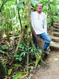
The guide also pointed out the "walking tree". It actually walks! From its trunk, it has a number of root stalks into the ground - kind of like an 8-legged stool. It sends out a new root or roots in the direction it wants to go. Then it then kills the root(s) from the other side and the whole tree moves, up to 2 meters a year! 


The early afternoon came with its typical threatening rain as we headed back into the Andes. The canyon route we took was known as the Route of the Waterfalls. Not long into the recesses of the mountains, the Amazon's moisture was blocked and we were saved from too much of a soaking. By late afternoon and after much twisting and turning blacktop behind us and after numerous tunnel passages, we came to a delightful area and town called Baños de Agua Santa. The town is a focal point for many eco activities. Being at the base of an active volcano, there are hikes with spectacular views of not only the volcano itself, but cascading rivers with rafting, zip-lines, etc.

Just outside of Baños, we rode a tram a couple hundred feet over the main river to the other side and then zip-lined back. There were 2 awesome waterfalls right under us. We had to hike up a bit and then zip-lined back on a different cable line over to the right of the tram.

2 waterfalls below the tram heading over to the other side

With afternoon light running out, we were sent to Baños town Centro and what a delightful surprise to find a charming colonial town nestled neatly between the steep cliffs. There was no lack of finding hotel space or restaurants, and once we checked in, we wandered the streets with bustling pedestrians and settled in a great little restaurant with some wonderful eastern cuisine. It also shows free movies every night in another room!

Accomplished 195 km today.